Local News Video
Lost Towns of Hancock County
SUMMARY: In Hancock County, communities like Bay St. Louis and Diamond Head are familiar, but five towns were displaced decades ago for the Stennis Space Center and its buffer zone. Established in 1961, Stennis required clearing nearly 140,000 acres, leading to the relocation of Santa Rosa, Westonia, Napoleon, Gainesville, and Logtown, impacting around 700 families. While some residents moved willingly, others resisted, exemplified by an elderly woman who insisted on moving her house. Despite the loss, many descendants now work at Stennis. A memorial event, “From Roots to Rockets,” is scheduled for November 2, honoring these lost communities and their families.


SUMMARY: WXXV’s Student Athlete of the Week is Parker Talley from St. Patrick. A senior swimmer, Parker began swimming in seventh grade and has excelled in multiple events, especially the 500-yard freestyle, where he set a personal best of 5:45.61 at last season’s state championship. He helped St. Patrick win the 2024 South State Championship and earned top finishes in relay races. Academically gifted with a 4.1 GPA and a 35 ACT, Parker was accepted to Mississippi State’s Shackles Honors College for mechanical engineering. He leads as swim team captain and is active in honor societies, archery, and robotics, cherishing his teammates like family.
SUMMARY: William Carey University is hosting its traditional “Tailgates and Tourniquets” blood drive on campus today until 2 p.m. Donors are encouraged to wear attire representing their favorite football team. Those who participate will receive free T-shirts while supplies last. The event includes informational booths focused on health and wellness, along with refreshments and music to create a lively atmosphere. This community event aims to bring people together to support a vital cause through blood donation, combining school spirit and community involvement in a festive setting.
The blood drive was held at the William Carey University Tradition Campus.
For more Local News from WLOX: https://www.wlox.com/
For more YouTube Content: https://www.youtube.com/channel/UCQZgBHlQMqHUV_hf4_9jLLQ
SUMMARY: On this Thursday evening at the Silver Slipper Casino, skies are mostly clear with some passing clouds and a little more humidity than yesterday. Coastal temperatures are in the upper 80s, rising to the mid-90s inland, such as 94 at Wiggins. Winds from the south are steady at 10 mph along the coast, bringing Gulf moisture and higher dew points, making overnight temperatures warmer in the upper 60s to mid-70s. Light scattered showers possible tonight, with southern winds returning tomorrow, keeping highs in the low to mid-90s. Cloud cover will increase Saturday ahead of a cold front bringing isolated showers Sunday and Monday, then cooler temperatures with highs in the mid-80s.

Jackson State alum Tramell Tillman wins Emmy for ‘Severance’ role

Mobile opioid addiction treatment in Tennessee requires workarounds, for now

Orlando restaurant owner invites artists to parking lot amid federal fight against street art

White House officials hold prayer vigil for Charlie Kirk

Frustrated with poor play against UTEP, Arch Manning will 'get back to basics'

Amazon’s Zoox launches its robotaxi service in Las Vegas

Charlie Kirk murder suspect ‘not cooperating’ with authorities, says Utah governor

Beaufort County warns of rabies and distemper threat to pets, animal officials urge vaccinations

Jonesboro band culture responsible for global legacy | FOX 5

Community honors life of 10-year-old Harper Moyski, killed in shooting at Minneapolis church

Alabama lawmaker revives bill to allow chaplains in public schools

Protesters in D.C. flood the streets demanding an end to Trump’s military deployment

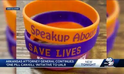
‘One Pill Can Kill’ program aims to reduce opioid drug overdose

1587 Prime gives first look at food, cocktail menu ahead of grand opening in KC

Interview: Come see Baptist at WTVA Senior Health Fair

Arkansas’s morning headlines | Sept. 9, 2025

Pulaski County town faces scrutiny after fatal overdose

‘Resilience and hope’ in Galveston: 125 years after greatest storm in US history | Texas

Man tries to save driver in deadly I-85 crash | FOX 5 News

Presidents are taking longer to declare major natural disasters. For some, the wait is agonizing
White House officials hold prayer vigil for Charlie Kirk
Jonesboro band culture responsible for global legacy | FOX 5

Family, friends hold candlelight vigil in honor of Giovanni Pelletier

Manhunt ends with arrest, new charges for alleged child killer | FOX 5 News

A look at recent flooding across South Florida

Ohio neighborhood fears landslide as retaining wall slips

Summer like temperatures continue

A very dry September forecast with hot afternoons ahead for Alabama.

Possibility of minor flooding in Miami, Fort Lauderdale and Key West due to high tides Sunday

Weather Impact Update for September 13
-

 News from the South - Alabama News Feed6 days ago
Alabama lawmaker revives bill to allow chaplains in public schools
-
News from the South - West Virginia News Feed7 days ago
Protesters in D.C. flood the streets demanding an end to Trump’s military deployment
-
News from the South - Arkansas News Feed7 days ago
‘One Pill Can Kill’ program aims to reduce opioid drug overdose
-
News from the South - Missouri News Feed7 days ago
1587 Prime gives first look at food, cocktail menu ahead of grand opening in KC
-
Mississippi News Video7 days ago
Interview: Come see Baptist at WTVA Senior Health Fair
-
News from the South - Arkansas News Feed6 days ago
Arkansas’s morning headlines | Sept. 9, 2025
-
News from the South - Missouri News Feed6 days ago
Pulaski County town faces scrutiny after fatal overdose
-
 News from the South - Texas News Feed6 days ago
‘Resilience and hope’ in Galveston: 125 years after greatest storm in US history | Texas