Local News Video
LIVE: Gusts pick up in Biloxi as Hurricane Francine makes landfall in Louisiana
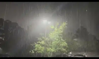
SUMMARY: Maya Turner reports from Buoy, where conditions have worsened throughout the day due to a storm. Initially, the area provided shelter for those seeking refuge, but heavy rain began by 4 PM, creating choppy waves at Point Cadet. Despite a voluntary evacuation, many boat owners chose to leave their vessels tied up. The Pops Ferry Causeway is experiencing strong winds, although rainfall has eased. Flooding is reported on Highway 90, prompting caution for drivers. Schools will close for the day but are expected to reopen Friday. Turner promises to keep updates coming as the situation evolves.
Miya Turner gives a live look of Hurricane Francine from Biloxi.
For more Local News from WLOX: https://www.wlox.com/
For more YouTube Content: https://www.youtube.com/channel/UCQZgBHlQMqHUV_hf4_9jLLQ


SUMMARY: South Mississippi will start the week with scattered showers and thunderstorms, especially Monday and Tuesday, with 1-2 inches of rain possible. Temperatures remain hot and humid, mostly in the upper 80s to low 90s. A cold front will bring more rain chances before a high-pressure ridge builds midweek, lowering rain chances by Wednesday through Friday. The Fourth of July looks mostly dry but very hot, with highs possibly in the mid to upper 90s and heat indices above 100. A low-pressure area near the Gulf or East Coast could develop into a tropical system by next weekend, bringing heavy rain, but details remain uncertain.
Meteorologist Taylor Graham explains how a soggy start to the week could be in the cards for South Mississippi.
Local News Video
Tropical Depression Two nearing coast of Mexico, low development chance in the Northeast Gulf
SUMMARY: Tropical Depression Two is nearing the coast of Mexico, expected to make landfall within 12 to 24 hours, with a brief chance of strengthening into Tropical Storm Barry. It remains disorganized and weak, likely to dissipate quickly after landfall. Meanwhile, South Mississippi is experiencing a rainy Sunday morning with showers and storms moving onshore, accompanied by hot temperatures and heat indices near 100-105°F. Afternoon and evening storms may bring gusty winds and lightning. A front drifting offshore in the northeastern Gulf could bring tropical development in the next 5-7 days but poses no immediate threat to the area. Rain chances remain high into the week.
Meteorologist Aaron Colby has the latest details on Tropical Depression Two, which is nearing the coast of Mexico.
SUMMARY: South Mississippi will experience scattered showers and thunderstorms over the next few days, especially from late morning to early afternoon, with some storms potentially producing heavy rain and isolated flooding. Temperatures will remain hot and humid, mostly in the upper 80s to low 90s. Rain chances may lessen slightly by Thursday and Friday, but hit-or-miss storms are still possible during the Fourth of July holiday. A new tropical depression formed in the southern Gulf of Mexico, expected to strengthen briefly before making landfall in Mexico, posing no threat to South Mississippi. Residents should stay alert as the hurricane season progresses.
Meteorologist Taylor Graham gives this week’s expected forecast and the latest update oin tropical development.

Trump admin looks to dismantle Tren De Aragua

Judge again delays Abrego Garcia’s release from Tennessee jail over deportation concerns

Judge will instruct jury to continue deliberations amid juror issue

DeSantis signs a slimmed-down Florida budget into law after vetoing millions

MAP: Which school districts increased teacher pay for the 2025-26 school year?

Kentucky State Police takes to the skies in National Cruiser Contest

Kenyan civilian shot at close range by police during protests dies

Red, White & Blue in the Loo

Tillis criticizes Trump's big tax bill on Senate floor, says he won't run again

The payment trick that’s costing used car buyers and sellers thousands

Thieves take thousands of dollars in equipment from Union County Soccer League

Defendant in auditor’s ‘second largest’ embezzlement case in history goes free

Robert Nichols to retire from Texas Senate

3 lawsuits filed against CVS, Louisiana AG announces

Residents provide feedback in Kearney Street Corridor redevelopment meeting

News 5 NOW at 12:30pm | June 24, 2025

The Vera C. Rubin Observatory will help astronomers investigate dark matter, continuing the legacy of its pioneering namesake

DeSantis signs bill into law that ensures public access to Florida beaches | Florida

The Rio Grande Valley as Heart of LGBTQ+ Resistance and Joy

Memphis officer shot, killed man with screwdriver inside of gas station, TBI says
Trump admin looks to dismantle Tren De Aragua
Judge will instruct jury to continue deliberations amid juror issue
Red, White & Blue in the Loo
Tillis criticizes Trump's big tax bill on Senate floor, says he won't run again
The payment trick that’s costing used car buyers and sellers thousands

Don't get burned by believing summer sun myths

Senate continues debating Trump’s “Big Beautiful Bill”

Local Party Leaders Response to Trump's Bill

Yes, the chance of rain is a true percentage of when you might see rain

FIRST ALERT: Rain expected to kick off the week (06/29/2025)
-

 News from the South - Tennessee News Feed6 days ago
Thieves take thousands of dollars in equipment from Union County Soccer League
-
Mississippi Today4 days ago
Defendant in auditor’s ‘second largest’ embezzlement case in history goes free
-
News from the South - Texas News Feed6 days ago
Robert Nichols to retire from Texas Senate
-
News from the South - Louisiana News Feed6 days ago
3 lawsuits filed against CVS, Louisiana AG announces
-
News from the South - Missouri News Feed6 days ago
Residents provide feedback in Kearney Street Corridor redevelopment meeting
-
News from the South - Alabama News Feed6 days ago
News 5 NOW at 12:30pm | June 24, 2025
-
The Conversation6 days ago
The Vera C. Rubin Observatory will help astronomers investigate dark matter, continuing the legacy of its pioneering namesake
-
 News from the South - Florida News Feed6 days ago
DeSantis signs bill into law that ensures public access to Florida beaches | Florida