Local News Video
Highway 49 rollover crash leaves 3 injured, shuts down lanes
SUMMARY: The news for South Mississippi starts at five. Karen Abernathy reports on a wreck on Highway 49 causing one person to be ejected from a vehicle. State Highway Patrol officials are still trying to piece together exactly what happened, but two people were reportedly injured. Mississippi Highway Patrol Trooper Cal Robertson tells us it was a rollover wreck and a helicopter was on the scene. This is the top news for South Mississippi at five.
A crash on Highway 49 Wednesday afternoon left three people injured and traffic in the area congested.
For more Local News from WLOX: https://www.wlox.com/
For more YouTube Content: https://www.youtube.com/channel/UCQZgBHlQMqHUV_hf4_9jLLQ


SUMMARY: South Mississippi’s Thursday forecast calls for near-normal temperatures with fewer showers than recent days. Tropical activity includes Tropical Storm Dexter with 50 mph winds, a weakening system off the East Coast with a 30% development chance, and another disturbance in the central Atlantic that could become the next named storm. Locally, calm seas and mostly clear skies are expected, with isolated afternoon coastal showers and thunderstorms possible. Friday should be drier, but rain chances rise again over the weekend and early next week due to a low south of the area. Increased rain next week will slightly cool temperatures.
SUMMARY: South Mississippi faces a hot, humid Thursday with afternoon storms possible. Thunderstorms are developing mainly over Stone and George counties but may weaken as daytime heating fades. Rain chances tonight are low but not zero. Tomorrow mirrors today with coastal showers and scattered afternoon storms, temperatures near 90°F, and heat indices reaching 105°F where storms are absent. Offshore winds will be light, with variable gusts near storms. Water temps are in the upper 80s. No Gulf tropical threats currently, but the Atlantic’s tropical wave Invest 96L is being watched for gradual development. The 7-day forecast calls for ongoing hot, humid weather with scattered storms.
Chief Meteorologist Eric Jeansonne explains why typical South Mississippi weather is to be expected along with why storms can’t be ruled out.
SUMMARY: Sparklight is helping Coast families with back-to-school costs by giving out 400 backpacks filled with essential school supplies. Starting today, 100 of these backpacks will be available at four locations in Biloxi, Gulfport, Long Beach, and Pascagoula. The backpacks and supplies are being distributed on a first-come, first-serve basis, with one backpack allowed per family. The event included food, fellowship, and fun activities for kids, such as bounce houses, creating a community atmosphere while supporting local students and families preparing for the new school year.
The company is giving out approximately 400 free backpacks filled with essential school supplies.
For more Local News from WLOX: https://www.wlox.com/
For more YouTube Content: https://www.youtube.com/channel/UCQZgBHlQMqHUV_hf4_9jLLQ

CDC shooter believed COVID vaccine made him suicidal, his father tells police

Hundreds cheer Arizona Sen. Ruben Gallego as Democrats take offensive against Trump’s tax bill

Dollywood shares hints about new attraction coming in 2026

Here's what Yadier Molina said on his first game as a Cardinals coach

Shooter who attacked the CDC headquarters was a 30-year-old man from suburban Atlanta

GBI identifies Emory University, CDC shooting suspect

Israel faces growing global condemnation over military expansion in Gaza

Governor to set limits on SNAP benefits.

Local movie: Catching Bullets

First West Nile Virus death reported in Mississippi for 2025

After 30 years in prison, Mississippi woman dies from cancer she says was preventable

Texas redistricting: What to know about Dems’ quorum break

Woman charged after boy in state’s custody dies in hot car

Two people unaccounted for in Spring Lake after flash flooding
Warning for social media shoppers after $22K RV scam

Georgia lawmakers to return this winter to Capitol chambers refreshed with 19th Century details

Chapel Hill family starts nonprofit after twin daughters diagnosed with rare disease

Pritzker says Texas Democrats who fled state will be protected amid arrest threats

Brain drain: Mother understands her daughters’ decisions to leave Mississippi

29-year-old killed after driving off road in 'dangerous' section road | FOX 5 News
GBI identifies Emory University, CDC shooting suspect
Governor to set limits on SNAP benefits.
Local movie: Catching Bullets
First West Nile Virus death reported in Mississippi for 2025

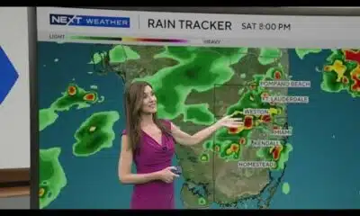
Scattered storms expected this weekend in South Florida. Next Weather team shows timeline.

Friends mourn and rally support after death of 6-year-old Odin Upton

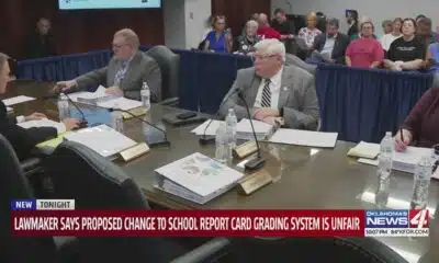
Lawmaker says proposed change to school report card grading system is unfair

Police found a man stabbed to death in St. Louis. They arrested his stepson in Minnesota a day later

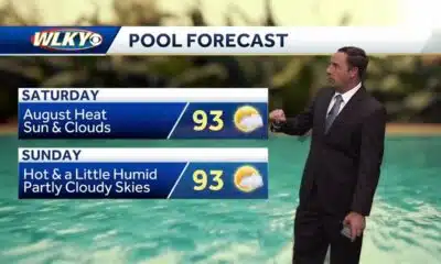
August heat continues for the weekend

Community Fundraisers Support Family of Mountain Gap Student Killed on Bike | Aug. 8, 2025 | News 19
-

 Mississippi Today5 days ago
After 30 years in prison, Mississippi woman dies from cancer she says was preventable
-
News from the South - Texas News Feed5 days ago
Texas redistricting: What to know about Dems’ quorum break
-
News from the South - Georgia News Feed7 days ago
Woman charged after boy in state’s custody dies in hot car
-
News from the South - North Carolina News Feed3 days ago
Two people unaccounted for in Spring Lake after flash flooding
-
News from the South - Florida News Feed6 days ago
Warning for social media shoppers after $22K RV scam
-
News from the South - Georgia News Feed6 days ago
Georgia lawmakers to return this winter to Capitol chambers refreshed with 19th Century details
-
News from the South - North Carolina News Feed7 days ago
Chapel Hill family starts nonprofit after twin daughters diagnosed with rare disease
-
News from the South - Texas News Feed6 days ago
Pritzker says Texas Democrats who fled state will be protected amid arrest threats