Local News Video
06/09 Ryan’s “Rainy Week” Monday Morning Forecast
SUMMARY: Monday’s forecast calls for a 50% chance of afternoon showers and thunderstorms, with a slight level two severe weather risk. Dry air still dominates, but a frontal system from the northwest and moisture in southern Mississippi will bring scattered storms through midweek. Temperatures remain hot and humid, peaking near 90°F today, then cooling slightly to the upper 80s later in the week due to cloud cover and rain. Heavy rainfall may cause localized flooding Wednesday through Friday. The northern half of the state will be drier and cooler, while southern areas face lingering showers into the weekend.


SUMMARY: The Hanshaw Road Bridge in Ocean Springs has reopened to traffic after being closed in March by state officials for necessary repairs. Jackson County funded the replacement and repair work. While crews are still reattaching water and sewer lines over the coming days, traffic is now able to move over the bridge again. However, these ongoing utility reconnections mean traffic may be reduced to one lane at times during the final stages of the repair process. The bridge reopening restores an important route for the Ocean Springs community after months of closure.
Over the next few weeks, work crews will install water and sewer lines on the side of the bridge.
For more Local News from WLOX: https://www.wlox.com/
For more YouTube Content: https://www.youtube.com/channel/UCQZgBHlQMqHUV_hf4_9jLLQ
SUMMARY: Sam Lucey’s Wednesday night forecast for South Mississippi highlights ongoing rain and thunderstorms, mainly driven by a seabreeze. This evening, storms are pushing offshore, leaving scattered light rain mainly in Jackson County. Temperatures remain steady in the mid-70s with mild humidity and southerly winds around 7 mph. Overnight rain chances are low at 20%. Thursday will see highs near 89°F with a mix of clouds and sun, and showers or storms forming mostly north of I-10 by late morning to early afternoon. The tropics remain quiet, and rain chances hold steady at 50-60%, rising to 70% Sunday. Temperatures stay in the upper 80s into next week.
SUMMARY: South Mississippi’s “Weather Kid Wednesday” features Nora, a young local who enjoys meteorology and sharing weather forecasts. Today’s forecast shows mostly sunshine early, with showers and thunderstorms expected later, including potential heavy rain. Nora likes playing board games and jumping in puddles on rainy days but knows to stay indoors if there’s lightning. The radar indicates some rain activity, with green showing light rain and red indicating heavy rain or storms. Although tornadoes aren’t expected today, safety tips like sheltering in a closet or bathtub are discussed. Nora finishes with a cheerful dance and high five.

Kilgore, Va. House GOP members slam Spanberger’s newly unveiled energy plan

Tennessee launches its summer food benefits this week. Most students in the state will miss out.

Break-in leads to shootout at Hendersonville store, police say

12 Florida bills sent to DeSantis’ desk. Here’s what happens if he signs them

Young Quarterback room vying for New Orleans Saints starting position

'We're just doing our best to survive': Charlton County Commission approves expansion of ICE Facility

Judge blocks Trump’s National Guard deployment in Los Angeles

Judge says Trump takeover of California National Guard ‘illegal,’ orders return to governor

DHR Investigator Testifies Autumn Wells Sleep Setup Did Not Meet State Standards | June 12, 2025 | N

Marsha Edwards, President and CEO of the Martha O’Bryan Center, Announces Departure in 2026 – The Tennessee Tribune

New Video: No Air Conditioning on Delta flight leaving Savannah, man collapses

South Florida weather for Friday 6/6/25

Unsettled weather pattern kicks in for the weekend

Florida Gov. DeSantis approves latest batch of laws. Here’s the full list

Mississippi seeing a shortage of physical therapists

Southern Magnolia – More Than Just a Pretty Flower

Republicans in Congress axed the ‘green new scam,’ but it’s a red state boon

Federal judge approves $2.8B settlement, paving way for colleges to pay athletes millions

Federal panel rules in favor of state in Arkansas congressional redistricting lawsuit

Transportation chief seeks to weaken fuel economy standards, calls Biden-era rule ‘illegal’
Break-in leads to shootout at Hendersonville store, police say
DHR Investigator Testifies Autumn Wells Sleep Setup Did Not Meet State Standards | June 12, 2025 | N

Scattered showers and storms return Friday & Saturday
Customers flirting with AI | FOX 5 News

Interview with Florida Panthers' Evan Rodrigues

Man speaks again in medical-first brain implant breakthrough

‘He’s our backbone’: Mother and wife fighting to bring her husband home from a immigration facility

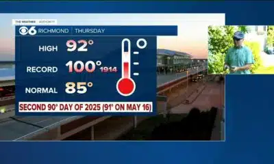
Richmond temps hit 90 for 2nd time this year; some storms return Friday

Power Swabs offers 50% off teeth whitening with free shipping!

South Florida Weather for Thursday 6/12/2025 12PM
-

 News from the South - Georgia News Feed6 days ago
New Video: No Air Conditioning on Delta flight leaving Savannah, man collapses
-
News from the South - Florida News Feed7 days ago
South Florida weather for Friday 6/6/25
-
News from the South - Kentucky News Feed7 days ago
Unsettled weather pattern kicks in for the weekend
-
News from the South - Florida News Feed6 days ago
Florida Gov. DeSantis approves latest batch of laws. Here’s the full list
-

 Local News6 days ago
Mississippi seeing a shortage of physical therapists
-
Our Mississippi Home6 days ago
Southern Magnolia – More Than Just a Pretty Flower
-
News from the South - Georgia News Feed7 days ago
Republicans in Congress axed the ‘green new scam,’ but it’s a red state boon
-
SuperTalk FM6 days ago
Federal judge approves $2.8B settlement, paving way for colleges to pay athletes millions