Local News Video
Family member speaks out after losing home to Christmas Eve fire
SUMMARY: The content is a message of gratitude, but it turns to discuss a home that was engulfed in a fire, leaving the Ramirez family without most of their belongings. Ramirez and her children escaped without injury, but their home suffered significant damage and is considered a total loss. The authorities are still searching for the cause of the fire. The family had lived in the home for about four years.
According to homeowner Nohelia Ramirez, she and her daughter were grocery shopping while her husbands and son were at the home.
For more Local News from WLOX: https://www.wlox.com/
For more YouTube Content: https://www.youtube.com/channel/UCQZgBHlQMqHUV_hf4_9jLLQ


Local News Video
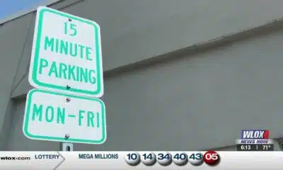
15-minute parking spots added in downtown Gulfport to ease congestion during renovations
SUMMARY: In Gulfport, eight temporary 15-minute parking spots are being added near the Hancock Whitney Bank to reduce congestion during upcoming renovations. The bank building, located across Highway 49, is set to be renovated, though no official start date has been determined. City leaders hope these short-term parking spots will ease traffic by accommodating customers using the bank’s drive-thru, where parking is currently limited, especially at peak times. These spots will remain in place until the renovation work is finished, improving access for customers to enter and exit quickly while construction occurs in downtown Gulfport.
Eight 15-minute parking spots will be temporarily added at the Hancock Whitney Bank in Gulfport. For more Local News from …
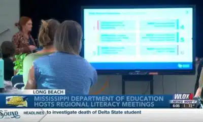
SUMMARY: The Mississippi Department of Education is hosting a series of statewide literacy meetings this month to improve reading skills and family engagement. One meeting took place at Reeves Elementary in Long Beach, aiming to review Mississippi’s Literacy-Based Promotion Act, a 2013 state law promoting comprehensive reading instruction for children. The department and Long Beach School District emphasize the importance of involving families in this process, as a solid literacy foundation benefits children’s lifelong learning and fluency. These meetings provide an opportunity to equip parents with effective tools to support their children’s literacy development and overall success in education and life.
The Mississippi Department of Education is hosting a series of literacy meetings across the state this month.
For more Local News from WLOX: https://www.wlox.com/
For more YouTube Content: https://www.youtube.com/channel/UCQZgBHlQMqHUV_hf4_9jLLQ
Local News Video
Saints Report: Saints lose another close game this time in week two against the San Francisco 49ers
SUMMARY: The New Orleans Saints lost a close game in week two against the San Francisco 49ers, 26-21, at the Caesar Superdome. Despite missing key 49ers players, the Saints struggled early but fought back with touchdowns by Rasheed Shahid and Devon Ble. A critical fourth-down sack of Spencer Rattler sealed their fate. Coach Kell Moore praised the team’s effort but emphasized the need for better situational play and seizing opportunities. The Saints aim to improve as they prepare to face the Seattle Seahawks next Sunday, September 21st. Reporting from the Caesar Superdome, Ever Gier Jr., WXXV News25 Sports.

Events happening this weekend in Mississippi: September 19-21

NCAA eliminates spring transfer period for football

Curtains Up: Theatre MSU Unveils Season of Classics, Musicals

US stocks churn amid uncertainty about how many more rate cuts are coming from the Fed
The Sound of the South: Mississippi’s Songbook

Prosecutors already have dropped nearly a dozen cases from Trump’s DC crime surge, judge says

15-minute parking spots added in downtown Gulfport to ease congestion during renovations

Statewide literacy meetings aim to boost reading skills and family engagement
Rep. Bennie Thompson calling on federal investigation into Delta State student’s death

A Sanctuary in Goodman: The Magic of the Public Library

Screech Owls – Small but Cute

NW Arkansas Championship expected to bring money to Rogers

What to know about Trump’s National Guard deployment to Memphis

New findings by NASA Mars rover provide strongest hints yet of potential signs of ancient life

What are data centers and why do they matter? | National

Rolling Through History: The Comfort and Culture of Dumplings

Is nail gel actually harmful? It's complicated

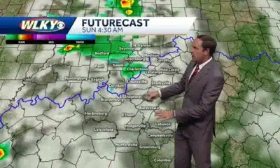
Few showers possible Saturday night into Sunday

Steven Spielberg celebrates ‘awesome’ 50th anniversary ‘Jaws’ exhibition at Academy Museum

Texas high school football scores for Friday, Sept. 12
15-minute parking spots added in downtown Gulfport to ease congestion during renovations
Statewide literacy meetings aim to boost reading skills and family engagement

Saints Report: Saints lose another close game this time in week two against the San Francisco 49ers

Harrison County approves budget with no tax increase

‘Little quiet light’: Family remembers Delta State University student found dead on campus

The Mustard Seed

WXXV Game of the Week: Week 3

White House officials hold prayer vigil for Charlie Kirk

Jonesboro band culture responsible for global legacy | FOX 5

Family, friends hold candlelight vigil in honor of Giovanni Pelletier
-

 Our Mississippi Home6 days ago
Screech Owls – Small but Cute
-
News from the South - Arkansas News Feed7 days ago
NW Arkansas Championship expected to bring money to Rogers
-
News from the South - Tennessee News Feed7 days ago
What to know about Trump’s National Guard deployment to Memphis
-
Local News6 days ago
New findings by NASA Mars rover provide strongest hints yet of potential signs of ancient life
-
 The Center Square5 days ago
What are data centers and why do they matter? | National
-
Our Mississippi Home5 days ago
Rolling Through History: The Comfort and Culture of Dumplings
-
News from the South - North Carolina News Feed7 days ago
Is nail gel actually harmful? It's complicated
-
News from the South - Kentucky News Feed7 days ago
Few showers possible Saturday night into Sunday