News from the South - Kentucky News Feed
Unsettled weather pattern kicks in for the weekend
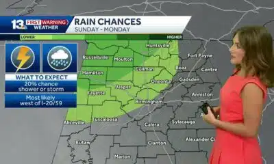
SUMMARY: The first week of June in Central and Eastern Kentucky has been warm with highs in the low to mid-80s and increasing humidity. A stalled front north of the area has caused scattered showers and severe storms with gusty winds and heavy rain. This front will linger through the weekend, maintaining unsettled weather. Saturday brings a higher risk of storms, especially in southern Kentucky, with damaging winds and localized flooding possible. Sunday will still see scattered storms and humidity. A cold front Monday will bring showers but clear skies and drier air are expected by Tuesday with pleasant temperatures near 80°F.
The post Unsettled weather pattern kicks in for the weekend appeared first on www.wtvq.com


News from the South - Kentucky News Feed
Inside look: Kentucky Army National Guard operations exercise
SUMMARY: The Kentucky Army National Guard conducted a weekend training exercise in Louisville to sharpen skills for responding to natural disasters like floods and tornadoes. The exercise included helicopter simulations to ensure smooth protocol and effective communication during emergencies. Battalion S-3 Operations Officer Jacob Conner emphasized the importance of realistic, progressive training with instructor pilots to prepare members for real-world scenarios. This rigorous preparation aims to build proficiency, teamwork, and confidence, ensuring the Guard can effectively support communities throughout Kentucky during crises. The training highlights the Guard’s commitment to readiness and service to the commonwealth.
Inside look: Kentucky Army National Guard operations exercise
WLKY is your home for Kentucky breaking news and weather. For your latest Kentucky news and weather visit: https://www.wlky.com/
For licensing inquiries: https://www.wlky.com/licensing
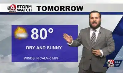
SUMMARY: Meteorologist Eric Zernich reports mostly dry, pleasant fall weather with clear skies and temperatures dipping into the 50s and 60s overnight. Most of the weekend stays dry, though a weak upper-level disturbance may bring a slight chance of showers late Saturday into Sunday morning, mainly in southern Indiana, but rain will likely fizzle due to dry conditions. Sunday will be warmer, reaching near 90°F, continuing into next week with summer-like heat in the 90s. Events like Bourbon and Beyond and the Gaslight Festival will enjoy mostly sunny skies, but attendees should stay hydrated as warm temperatures persist.
WLKY meteorologist Eric Zernich’s Friday night forecast
WLKY is your home for Kentucky breaking news and weather. For your latest Kentucky news and weather visit: https://www.wlky.com/
For licensing inquiries: https://www.wlky.com/licensing
News from the South - Kentucky News Feed
Trump says he’ll send National Guard to Memphis, escalating his use of troops in US cities
SUMMARY: President Donald Trump announced plans to deploy the National Guard to Memphis, Tennessee, to address crime concerns, claiming local officials support the move. Tennessee Governor Bill Lee welcomed the plan, while Memphis Mayor Paul Young opposed it, emphasizing community-focused solutions like rehabilitation and job support over military presence. Despite overall crime reductions and ongoing FBI operations, persistent gun violence and high-profile killings fuel concerns. Legal experts warn deploying troops for policing risks civil rights violations. Trump’s broader strategy involves sending troops to other Democratic-led cities, sparking political and legal debates over the use of military forces in domestic law enforcement.
The post Trump says he’ll send National Guard to Memphis, escalating his use of troops in US cities appeared first on www.wnky.com

Family, friends hold candlelight vigil in honor of Giovanni Pelletier

Steven Spielberg celebrates ‘awesome’ 50th anniversary ‘Jaws’ exhibition at Academy Museum

Rolling Through History: The Comfort and Culture of Dumplings

A look at recent flooding across South Florida

What are data centers and why do they matter? | National

Ohio neighborhood fears landslide as retaining wall slips
Southern Miss football beats App State for first Sun Belt win in nearly 2 years

A very dry September forecast with hot afternoons ahead for Alabama.

Luke Altmyer scores 3 TDs, No. 9 Illinois shuts out Western Michigan, 38-0

Possibility of minor flooding in Miami, Fort Lauderdale and Key West due to high tides Sunday

Protesters in D.C. flood the streets demanding an end to Trump’s military deployment

On the record: Winsome Earle-Sears

1587 Prime gives first look at food, cocktail menu ahead of grand opening in KC

‘One Pill Can Kill’ program aims to reduce opioid drug overdose

Interview: Come see Baptist at WTVA Senior Health Fair

How is paint made?

Alabama lawmaker revives bill to allow chaplains in public schools

Arkansas’s morning headlines | Sept. 9, 2025

‘Resilience and hope’ in Galveston: 125 years after greatest storm in US history | Texas

Pulaski County town faces scrutiny after fatal overdose
Family, friends hold candlelight vigil in honor of Giovanni Pelletier
A look at recent flooding across South Florida
Ohio neighborhood fears landslide as retaining wall slips
A very dry September forecast with hot afternoons ahead for Alabama.
Possibility of minor flooding in Miami, Fort Lauderdale and Key West due to high tides Sunday

Panic and chaos at a St. Louis area mall false reports of shots fired

Christian's Latest Forecast: More Dry Days; Rain Potential Late Next Week

NC Courage wins 2-1 against Angel City FC

Inside look: Kentucky Army National Guard operations exercise

Some employers take action against employees for social media comments on Charlie Kirk's death
-

 News from the South - West Virginia News Feed7 days ago
Protesters in D.C. flood the streets demanding an end to Trump’s military deployment
-
News from the South - Virginia News Feed7 days ago
On the record: Winsome Earle-Sears
-
News from the South - Missouri News Feed6 days ago
1587 Prime gives first look at food, cocktail menu ahead of grand opening in KC
-
News from the South - Arkansas News Feed6 days ago
‘One Pill Can Kill’ program aims to reduce opioid drug overdose
-
Mississippi News Video6 days ago
Interview: Come see Baptist at WTVA Senior Health Fair
-
The Conversation7 days ago
How is paint made?
-
News from the South - Alabama News Feed6 days ago
Alabama lawmaker revives bill to allow chaplains in public schools
-
News from the South - Arkansas News Feed6 days ago
Arkansas’s morning headlines | Sept. 9, 2025