Local News Video
Tropical Storm Update: Projected Hurricane Francine aimed for Louisiana
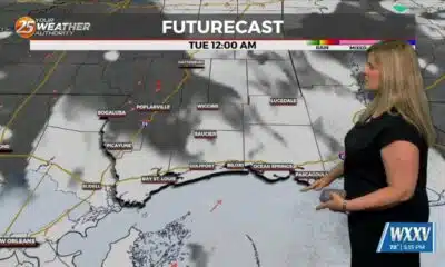
SUMMARY: Meteorologist Trey Tonis provided an update on Tropical Storm Francine, which is expected to approach Southeastern Louisiana as a potential hurricane. While residents of South Mississippi shouldn’t panic, preparation is key, including access to sandbag locations. The storm’s track indicates heavy rain and possible spin-up tornadoes in the area due to being on the “dirty side” of the storm. Current atmospheric conditions are favorable for storm development, and flooding risks are heightened by existing moisture from recent storms. The National Hurricane Center warns of storm surge impacts, especially for Louisiana. More updates will follow throughout the evening.
(9/9) Monday: Meteorologist Trey Tonnessen discusses with Grant Chighizola; what will be Hurricane Francine. Then he gives us an in depth analysis of the science behind this tropical system.


SUMMARY: Sam’s “Warm and Damp” Monday evening forecast reports recent rainfall totals: Bay St. Louis about 1.5 inches, Bualuxy and Ocean Springs under an inch, Gulfport half an inch, Lucale a quarter inch, and Pasigula a trace. A storm passed between 1:30 and 2:30 pm, with more rain expected over the next hours. The Mississippi radar shows heavy rain moving southeast. An aerial flood advisory is in effect due to heavy weekend and recent rain. Temperatures are warm and humid, around mid-70s to low 90s. Rain chances will increase early Tuesday, with cloud cover limiting afternoon highs. A drier, hot Fourth of July is forecast.
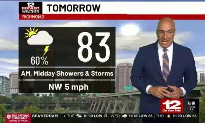
SUMMARY: South Mississippi will start the week with scattered showers and thunderstorms, especially Monday and Tuesday, with 1-2 inches of rain possible. Temperatures remain hot and humid, mostly in the upper 80s to low 90s. A cold front will bring more rain chances before a high-pressure ridge builds midweek, lowering rain chances by Wednesday through Friday. The Fourth of July looks mostly dry but very hot, with highs possibly in the mid to upper 90s and heat indices above 100. A low-pressure area near the Gulf or East Coast could develop into a tropical system by next weekend, bringing heavy rain, but details remain uncertain.
Meteorologist Taylor Graham explains how a soggy start to the week could be in the cards for South Mississippi.
Local News Video
Tropical Depression Two nearing coast of Mexico, low development chance in the Northeast Gulf
SUMMARY: Tropical Depression Two is nearing the coast of Mexico, expected to make landfall within 12 to 24 hours, with a brief chance of strengthening into Tropical Storm Barry. It remains disorganized and weak, likely to dissipate quickly after landfall. Meanwhile, South Mississippi is experiencing a rainy Sunday morning with showers and storms moving onshore, accompanied by hot temperatures and heat indices near 100-105°F. Afternoon and evening storms may bring gusty winds and lightning. A front drifting offshore in the northeastern Gulf could bring tropical development in the next 5-7 days but poses no immediate threat to the area. Rain chances remain high into the week.
Meteorologist Aaron Colby has the latest details on Tropical Depression Two, which is nearing the coast of Mexico.

Trump nominates Baxter Kruger, Scott Leary for Mississippi U.S. attorney posts

Jury reaches verdict on 4 of 5 counts in Diddy trial but is told to keep deliberating

Arkansans paying millions more in tariff costs compared to 2024

‘Alligator Alcatraz’ Opens in Florida amid protests, praise, and legal threats

Senate megabill marks biggest Medicaid cuts in history

Summer Rodeo and Country Music Fest Series

July 4 travel tips as people hit the road

Health survey seeks to improve Western Tidewater community care

Officials react to Senate passage of ‘One Big Beautiful Bill’

Democrats face harsh reality as voters change party affiliation, Dems need to change their strategy

Defendant in auditor’s ‘second largest’ embezzlement case in history goes free

From ‘I’m Bored’ to ‘Let’s Explore’: A Summer Scavenger Hunt Through Mississippi History

Residents provide feedback in Kearney Street Corridor redevelopment meeting

The Rio Grande Valley as Heart of LGBTQ+ Resistance and Joy

Louisiana’s energy efficiency ‘slush fund’: $80 million, few rules

Are you addicted to ‘fridge cigarettes’? Here’s what the Gen Z term means

Marcos Lopez arrest: Owner of club named in RICO document

Country singer’s teeth fall out on stage

Democrats pour $400K into Virginia House races as key battlegrounds emerge

Mid-South mayor arrested, accused of tax evasion, police say
Summer Rodeo and Country Music Fest Series
July 4 travel tips as people hit the road
Health survey seeks to improve Western Tidewater community care

Sam's “Warm and Damp” Monday Evening Forecast

Clinton police investigate after man killed in shooting

South Florida surgeon committed to helping others beyond the operating room

Tuesday forecast: First Alert Weather day

More downpours Tuesday, drier tomorrow

Man caught stealing $3K worth of fireworks from stand

“A miracle”: Florida family captures dramatic rescue after 2 go overboard on Disney cruise
-

 Mississippi Today5 days ago
Defendant in auditor’s ‘second largest’ embezzlement case in history goes free
-
News from the South - Missouri News Feed7 days ago
Residents provide feedback in Kearney Street Corridor redevelopment meeting
-
Our Mississippi Home6 days ago
From ‘I’m Bored’ to ‘Let’s Explore’: A Summer Scavenger Hunt Through Mississippi History
-
News from the South - Louisiana News Feed7 days ago
Louisiana’s energy efficiency ‘slush fund’: $80 million, few rules
-
News from the South - Georgia News Feed4 days ago
Are you addicted to ‘fridge cigarettes’? Here’s what the Gen Z term means
-
News from the South - Texas News Feed7 days ago
The Rio Grande Valley as Heart of LGBTQ+ Resistance and Joy
-
News from the South - Florida News Feed6 days ago
Marcos Lopez arrest: Owner of club named in RICO document
-
News from the South - Tennessee News Feed6 days ago
Mid-South mayor arrested, accused of tax evasion, police say