News from the South - Kentucky News Feed
Traditional ‘Tornado Alley’ shifts eastward as climate changes, says meteorologist studying trend
by Kenneth Heard, Kentucky Lantern
May 19, 2025
In the 30 days after several damaging twisters hit Arkansas on March 14, the state saw nearly four times as many tornado warnings as Texas did.
The National Weather Service issued 144 warnings in Arkansas, compared to 39 in Texas from March 14 to April 14. Mississippi also recorded 144 warnings over the same period and Tennessee saw 125 warnings. Alabama noted 57 warnings.
It’s an indication that the classic “Tornado Alley” region — the area from central Texas through Oklahoma and Kansas, so named because of the number of tornadoes there — is shifting eastward.
The shift is attributed to climate change, the warming of the Gulf of Mexico’s waters and a dip in the cold jet stream pattern.
Arkansas, scientists say, is nearly in the bull’s eye of a new tornado-prone area that’s referred to as “Dixie Alley.” The region, which has seen a vast increase in tornadoes over the past several years, also encompasses Mississippi, Alabama and western Tennessee.
Weather Service survey teams have already confirmed 35 tornadoes have touched down in Arkansas through April. The state averages 42 twisters per year.
The storms have also been larger. Arkansas was hit with two EF-4 twisters on March 14 — one in Jackson County and one in Izard County
The last time a tornado of that strength hit the state was on April 27, 2014, when a tornado cut a 41-mile path of destruction through western Pulaski County, Mayflower and Vilonia in Faulkner County, and on into White County. Sixteen people died in that storm.
Victor Gensini, a professor of meteorology at Northern Illinois University in DeKalb, Illinois, conducted research about the shift, authoring a paper in 2018 that noted the change. Since then, he’s continued to monitor the trend and says the trend is ongoing.
“It’s still more prevalent in the southeast,” he said. “And we’re seeing more evidence of that each year.”
‘Drying up’
Gensini tracked tornado reports from 1979 to 2018 for his initial study, but also noted atmospheric conditions in the areas at the time that were favorable for the formation of tornadoes.
Gensini blames a combination of weather phenomenon for the increase in Arkansas’ tornadoes. A drought in the southwest is taking away needed moisture for the formation of twisters in the traditional Tornado Alley region.
More than 67% of Arizona is experiencing “extreme” and “exceptional” drought conditions — the two highest levels of drought, according to the U.S. Drought Monitor. The Drought Monitor is based at the University of Nebraska in Lincoln and records weather conditions and patterns weekly.
Three months ago, only 17% of Arizona was under the same two drought conditions. A year ago, the state was considered free from extreme and exceptional drought.
New Mexico, Texas and Utah have also seen increases in drought in their respective states. Thirty percent of Texas is in “extreme” and “exceptional” drought, an increase from 14% three months ago.
“The most intense levels of drought now cover a broad area from southeastern California, southern Nevada, and southwestern Utah through much of Arizona, New Mexico and the Texas Big Bend, said Richard Tinker, a meteorologist with the Climate Prediction Center in College Park, Maryland, and the author of the latest drought report.
“The southern Great Plains are drying up,” Gensini added.
Faster rate of change
The dry atmospheric conditions in the southwest create a dome of high pressure over the western U.S., sapping energy from the atmosphere and forcing potential tornado-producing systems to move further east. The jet stream, a strong current of frigid Arctic air, is also dipping further south into the Mississippi delta region because of the Southwestern drought.
Water temperature in the Gulf has also increased on average by one or two degrees, creating the moist, humid air needed for tornadoes.
“One or two degrees may not seem much. But think of the difference between 32 degrees and 33 degrees,” Gensini said, referring to the temperature when water freezes. “It’s early in the season, and the waters are warmer. That warm, humid air is heading into Arkansas where the air has been unstable already. It makes things more potent.
“We’re seeing weather pattern changes over the last 70 to 80 years that didn’t happen in 100,000 to 120,000 years before,” he said. “There is such a rapid rate of change, and it’s not lessening.”
Of the 144 warnings issued in Arkansas between March 14 and April 14, not all produced tornadoes, said Dennis Cavanaugh, the National Weather Service warning coordinator in North Little Rock.
In fact, the Weather Service strives to keep its “false alarm” rate of tornado warnings to less than 80%. Warnings are issued when Doppler weather radar picks up rotation in clouds, signature “inflow notches” that indicate the building of cyclonic air patterns, hail cores and other indicators.
The Weather Service also must balance the need to warn people while also not unnecessarily alarming them. Issue too many warnings that don’t produce tornadoes, and the public may become complacent and not heed future warnings as seriously. John Robinson, a former Meteorologist in Charge at the North Little Rock station, used to say that more people were injured in tornadoes while gawking at clouds for confirmation of those tornadoes rather than seeking shelter when warnings were issued.
On the other side, if the Weather Service curtails its warnings and an unwarned tornado does form, results could be devastating.
“Radar can’t see tornadoes,” Cavanaugh said. “It can see circulation aloft when it’s likely a tornado is forming. If we wait to see the debris cloud from a tornado that’s on the ground to issue a warning, it’s much too late.”
More hail
Cavanaugh said continued advances in technology should help the Weather Service lower its rate of false alarms. But the service will always rely on trained storm spotters who can see the lowering of wall clouds — a first step in the formation of tornadoes — and any circulation of clouds overhead.
“That’s really not applicable to this year,” he said of the fear that the scores of warnings issued may eventually be ignored. “I don’t think the average Arkansan thought he or she was not warned unnecessarily.”
During a round of storms one April evening, Ryan Vaughn, the meteorologist for KAIT8 in Jonesboro, was broadcasting live storm coverage. At one point, most of northeast Arkansas was placed under a myriad of tornado warnings.
Vaughn took a deep sigh on air.
“I don’t think I’ve ever said this before, but if you’re anywhere in northeast Arkansas, take cover now,” he told viewers.
Tornadoes are formed by opposing winds at various levels. Strong winds in opposite directions cause a shear and a horizontal column of air circulating overhead. Warm, humid air feeds the twister and eventually the column of air begins tilting vertically and lowering to become a destructive tornado.
And if the increase in tornadoes in Arkansas and the Delta is not enough, Gensini said the ingredients for twister formation should also cause larger hail storms.
Hail is formed inside supercell thunderstorms. The rising air inside a building storm lofts raindrops into freezing air. It causes hail, which falls to the ground. Many times, a frozen raindrop falls in the size of a pea or gravel. But with more convection inside the stronger storms, that pea-sized bit of hail is lofted over and over again inside the system, growing larger as more water freezes on it.
That’s what causes the golf ball- and baseball-sized hail and are indicative of stronger storms and tornadoes.
Gensini is about to embark on a 40-day field study this summer of hail storms.
“Tornadoes get all the attention on the news because of the visual destruction,” he said. “You see a path of destruction with shattered homes. But hail is much worse overall. It damages roofs, cars and agriculture in a much larger area.
“I think the south and southeast will see a lot more problems in the years coming,” he said.
This article is republished from the Arkansas Advocate, a sister publication of the Kentucky Lantern and part of the nonprofit States Newsroom network.
GET THE MORNING HEADLINES.
Kentucky Lantern is part of States Newsroom, a nonprofit news network supported by grants and a coalition of donors as a 501c(3) public charity. Kentucky Lantern maintains editorial independence. Contact Editor Jamie Lucke for questions: info@kentuckylantern.com.
The post Traditional ‘Tornado Alley’ shifts eastward as climate changes, says meteorologist studying trend appeared first on kentuckylantern.com

Note: The following A.I. based commentary is not part of the original article, reproduced above, but is offered in the hopes that it will promote greater media literacy and critical thinking, by making any potential bias more visible to the reader –Staff Editor.
Political Bias Rating: Center-Left
This article primarily focuses on scientific explanations of changing weather patterns due to climate change, emphasizing expert opinions and observable data without overt political rhetoric. The acknowledgment of climate change as a significant factor in shifting tornado activity reflects typical center-left media perspectives that accept and highlight climate science. However, the piece remains factual and informative, avoiding strong ideological language or policy advocacy, placing it closer to a center-left but broadly factual stance.


News from the South - Kentucky News Feed
Online Rockcastle County program gives students learning flexibility
SUMMARY: Rockcastle County Schools in Kentucky continue their online learning program, now in its sixth year since starting during the pandemic. Designed for students in sixth grade and above, the program offers flexibility for those facing challenges with in-person attendance. District leaders emphasize that while in-person learning remains the preferred method, virtual education provides a valuable alternative for unique situations. The program resets each semester, allowing students to switch between online and in-person learning as needed. Families must sign a contract to commit to the program’s expectations, ensuring students benefit fully from this adaptable educational option in a digital world.
This school year marks the 6th year of the program, which began due to the pandemic.
Subscribe to FOX 56 News on YouTube: https://www.youtube.com/c/FOX56News/?sub_confirmation=1
Stay informed about central Kentucky news, weather, and sports! Follow FOX 56 on our website and social channels:
https://www.FOX56News.com
https://www.youtube.com/c/FOX56News
https://www.facebook.com/FOX56News
https://twitter.com/FOX56News
https://www.instagram.com/FOX56News
https://www.linkedin.com/company/FOX56News
SUMMARY: Alexander Laykovich, 27, from Milwaukee, Wisconsin, was sentenced to 48 months in prison by U.S. District Judge Karen Caldwell for unlawful possession of firearms despite being adjudicated as mentally defective in January 2023, which barred him from owning guns. He was stopped in Stanford, Kentucky, in January 2024, while carrying body armor, knives, a recording device, and eight firearms. Further searches revealed 15 more firearms and explosive device parts. Laykovich will serve 85% of his sentence and face five years of probation. The case involved cooperation among federal, state, and local law enforcement agencies and prevented potential violence near Fort Knox.
The post Wisconsin Man Sentenced for Illegal Firearm Possession appeared first on lexingtonky.news
SUMMARY: A Kansas man, 41-year-old Justin R. Bevitt of Topeka, is accused of meeting and engaging in sexual activities with a 15-year-old Kentucky girl. Kentucky State Police began investigating after receiving a report of a juvenile leaving home with Bevitt. The investigation revealed multiple past encounters between Bevitt and the minor. With help from the Warren County Commonwealth Attorney’s Office and the Kansas Bureau of Investigation, authorities searched Bevitt’s Topeka residence on August 22, leading to his arrest. He faces charges including procuring a minor, unlawful transactions, and distributing sexual material involving a minor. Extradition and additional charges are pending. The case remains under investigation.
The post Kansas man accused of child sex crimes in Kentucky appeared first on www.wnky.com

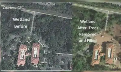
Environmental advocates file petition for rehearing in Glynn County wetlands case

'Bathroom bill' advances in Texas House days after tensions flared at hearing

After Trump and Congress spending cuts, public media stations wait on money for emergency alerts

After the Winds: Kindness in Katrina’s Wake

Child in north Alabama has measles, says Alabama Department of Public Health

“By the Grace of God, I’m still here:” Seminole man survives lightning strike outside pizza shop

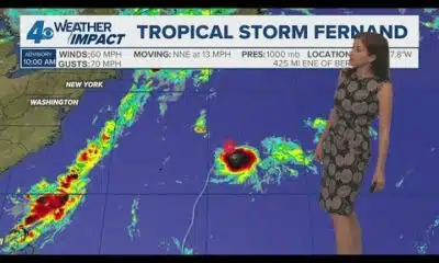
Monday Noon Tropics Update: Fernand heads north, Invest 99 fizzles

Texas House Republicans vote against retroactive punishments for quorum breakers

Southwest Airlines is changing its seating policy for larger customers

Getting a master’s degree in behavioral health? TN could help you pay for it

First of its kind clinical trial offers new hope for Kentuckians at risk of dementia

U.S. agriculture secretary announces end to subsidies for solar panels on farmland

Don't eat this shrimp sold at Walmart due to possible radiation contamination: FDA

Cities across the US are embracing AI guidelines for local government workers

Grants to boost local emergency alert systems in question as public media agency closes

Free AI testing platform rolled out to federal employees

‘Alligator Alcatraz’ probed by Dems as ICE detention centers multiply in states

MSU Unveils Mixed-Use Development Featuring Boutique Hotel, Cultural Landmark

New I-55 bridge between Arkansas, Tennessee named after region’s three ‘Kings’

The Innocent and the Executed: James Beathard’s Long-Forgotten Story
“By the Grace of God, I’m still here:” Seminole man survives lightning strike outside pizza shop
Monday Noon Tropics Update: Fernand heads north, Invest 99 fizzles

NAACP hosts annual Freedom Fund Banquet

Fever Five: Top highlights from Friday night’s high school football games (Week 1: Jamboree Edition)

DC teachers cheer ‘Not Like Us’ parody and $1,100 donation | NBC4 Washington

Online Rockcastle County program gives students learning flexibility

Fox 14 Your Morning News: Movement Monday

President Trump expands cities targeted for possible military deployment

Tips: Experts urge parents to address online safety with kids

Neighbor's camera captures suspect starting the fire
-

 News from the South - Alabama News Feed6 days ago
U.S. agriculture secretary announces end to subsidies for solar panels on farmland
-
News from the South - Kentucky News Feed6 days ago
First of its kind clinical trial offers new hope for Kentuckians at risk of dementia
-
News from the South - West Virginia News Feed7 days ago
Free AI testing platform rolled out to federal employees
-
News from the South - Georgia News Feed7 days ago
Don't eat this shrimp sold at Walmart due to possible radiation contamination: FDA
-
News from the South - Arkansas News Feed6 days ago
Cities across the US are embracing AI guidelines for local government workers
-
News from the South - Alabama News Feed5 days ago
Grants to boost local emergency alert systems in question as public media agency closes
-
News from the South - Arkansas News Feed6 days ago
‘Alligator Alcatraz’ probed by Dems as ICE detention centers multiply in states
-
Our Mississippi Home6 days ago
MSU Unveils Mixed-Use Development Featuring Boutique Hotel, Cultural Landmark