Connect with us

The Conversation

Rocks on Rapa Nui tell the story of a small, resilient population − countering the notion of a doomed overpopulated island

Published

on

theconversation.com – Carl Lipo, Professor of Anthropology and Associate Dean for Research, Binghamton University, State University of New York – 2024-06-21 13:05:50

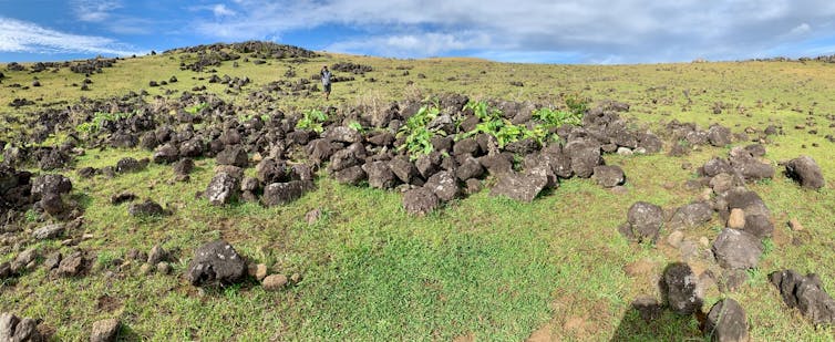
Covering the ground with rocks is actually a good way to grow some crops in poor soil.
Carl Lipo

Carl Lipo, Binghamton University, State University of New York

Conventional wisdom holds that the island of Rapa Nui, also known as Easter Island, once had a large population that crashed after living beyond its means and stripping the island of resources. A new research study my colleagues and I conducted has struck another blow to this notion by using artificial intelligence to analyze satellite data about piles of rocks on this tiny island in the middle of the Pacific Ocean.

Our study looked at rock gardens, a form of subsistence farming, and determined that the island – just 15.3 miles (24.6 km) long by 7.6 miles (12.3 km) at its widest point – likely never held many more than the 3,000 or so people European explorers encountered in 1722.

The conventional wisdom grew out of speculation about another set of stone structures on the island: the iconic massive statues, called moai, that ancestors of Rapanui people carved. The statues tower as high as a three-story building and weigh up to 70 tons. There are nearly 1,000 of them across the island.

For an archaeologist, the mystery of what led people to invest so much time and energy in building these colossal figures begs for an explanation. For the past 24 years, my colleagues and I have been searching for one.

Some of the earliest European visitors assumed that the island must have hosted a much larger population at one point to account for the number and magnitude of the moai. This assumption has been repeated for generations and forms the basis of a collapse narrative.

The collapse story holds that the island must have once had tens of thousands of inhabitants needed for the labor involved in carving and transporting the massive statues. Such a large population was not sustainable, and ultimately shortfalls in food resulted in starvation, warfare and even cannibalism. Consequently, the population plummeted to the meager numbers observed by the early European explorers.
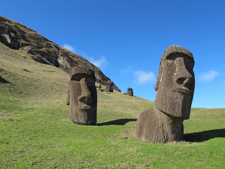
large stone carved heads sit on a grassy treeless aside
Did it really take an excessively large population to carve and transport these giant stone statues centuries ago?
AP Photo/Karen Schwartz

In our previous studies of the island my colleagues and I asked ourselves, if there were so many people living on the island at some point before European arrival, where is the evidence? We undertook a new study to examine whether such a large population was possible, given how Rapanui people used rock gardens to grow much of their food. From our evaluation of the available data, our best estimate is that there were never more than 3,000 to 4,000 people, and they lived sustainably on the island.

What rocks say about farming

In this study, we examined the archaeological record of how the Rapanui used rock gardening to grow their main crop, the sweet potato. Rock gardening is a form of cultivation in which broken pieces of bedrock are added to the soil to enrich it. Extensive rock garden cultivation plots are found across the island and would have provided a critical food source augmented by marine resources.

Previous studies have noted the extent of these gardens and concluded that these efforts might have supported up to 16,000 people. Our fieldwork, however, found that many of the areas that this study identified as rock gardens were misidentified. So we needed to conduct a more detailed analysis to get a better estimate of rock gardening, which would give us a more reliable source of information about maximum possible population sizes.

We combined fieldwork with new analyses of satellite imagery. During our fieldwork, we looked on the ground for clear examples of rock gardening. We knew we were at locations of rock gardening when we found patches covered with rocks in places that could not be easily explained as the result of erosion. Obsidian artifacts among the rocks confirmed that the areas were used for cutting and processing sweet potatoes. Often, these areas have another root crop, taro, growing in them even today. We also identified places that might resemble rock mulch gardens but were just bedrock outcrops or random scatters of cobbles and boulders.

We then acquired WorldView-3 satellite imagery for the entire island. The WorldView-3 satellite collects high-resolution visible light photos of the Earth’s surface and images that record shortwave infrared information. Shortwave infrared includes wavelengths that range between 900 nm and 2,500 nm, longer than are visible to the human eye. Shortwave infrared is helpful for distinguishing materials that look identical to the unaided eye. In particular, shortwave infrared is sensitive to differences in moisture, an essential attribute of productive agricultural fields.

Using our field data, we trained machine learning models to distinguish rock mulch gardening areas from those that are not. Machine learning generates an algorithm that can detect subtle differences – and can do so repeatedly and systematically. In this way, we could examine nearly the entire island quickly and without spending years doing field mapping.
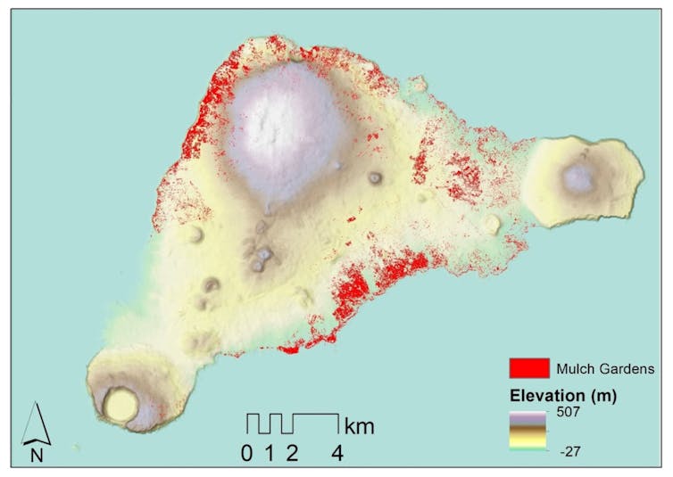
A map of a triangular shaped island
Red dots indicate rock gardens detected by satellite imagery.
Dylan Davis, CC BY

Our analyses dramatically reduced the island’s total area that can be associated with rock gardening, from a range of 1.6 to 8.1 square miles (4.3 to 21.1 square kilometers) down to 0.29 square miles (0.76 square kilometers). When we entered estimates for the productivity of these areas, our calculations showed that the maximum number of people this form of cultivation can support is about 3,000, quite similar to the conclusions we reached with other sources of information.

Resilience rather than hubris

Over the past 20 years, researchers have generated significant new evidence about the archaeological record of Rapa Nui, contributing to reframing the island’s narrative away from the idea of collapse. For example, studies from my team demonstrate that the statues were moved in a walking fashion from the quarry to their final locations on platforms called ahu. We have also tackled the question of how the islanders placed giant multiton hats called pukao on the tops of these statues.

However, the idea that there were much larger numbers of people on the island remains embedded in the academic and popular literature. The persistence of this idea has consequences outside of the field of Rapa Nui archaeology. Despite archaeological evidence to the contrary, it is not uncommon, for example, for ecologists to use Rapa Nui as a case study of so-called Malthusian demographics, where the population is assumed to have reached a massive peak that momentarily outstripped the island’s resources and triggered an ecological catastrophe.

While my colleagues and I agree that it is essential to be concerned about the potential for exploitation of natural resources, catastrophe is not the only possibility. Human history offers many examples demonstrating how it is possible to live sustainably despite constraints.

On Rapa Nui, we have learned that its people did not experience a population collapse before the arrival of Europeans but instead succeeded due to their ingenuity. Rapanui people found clever ways of adapting to the island and practiced sustainable farming to support themselves. This research project adds details about the capacity of rock gardens to grow food and support the population of the island.
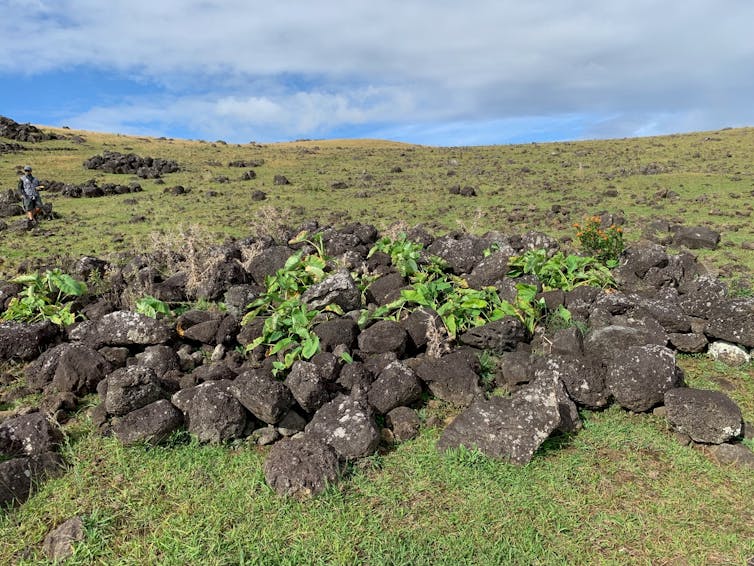
A pile of rocks on a sunny treeless hillside
Rock gardens add nutrients and retain moisture in poor soil.
Carl Lipo

Our increasing understanding of the island has critical implications for the future. In learning how to thrive in a limited environment, society can adopt strategies used by people in the past. The archaeological record of Rapa Nui points to the idea that efforts that bring communities together in cooperative and competitive ways, such as moai carving and transport, lead to greater resiliency in times of shortfall.

In the end, the history of Rapa Nui is not a cautionary tale but a source of inspiration that may be key to humanity’s future.The Conversation

Carl Lipo, Professor of Anthropology and Associate Dean for Research, Binghamton University, State University of New York

This article is republished from The Conversation under a Creative Commons license. Read the original article.

Read More

The post Rocks on Rapa Nui tell the story of a small, resilient population − countering the notion of a doomed overpopulated island appeared first on theconversation.com

The Conversation

AI was everywhere in 2024’s elections, but deepfakes and misinformation were only part of the picture

Published

on

theconversation.com – Bruce Schneier, Adjunct Lecturer in Public Policy, Harvard Kennedy School – 2024-12-02 07:37:00

AI played many roles in 2024’s elections.

AP Photo/Paul Vernon

Bruce Schneier, Harvard Kennedy School and Nathan Sanders, Harvard University

It’s been the biggest year for elections in human history: 2024 is a “super-cycle” year in which 3.7 billion eligible voters in 72 countries had the chance to go the polls. These are also the first AI elections, where many feared that deepfakes and artificial intelligence-generated misinformation would overwhelm the democratic processes. As 2024 draws to a close, it’s instructive to take stock of how democracy did.

In a Pew survey of Americans from earlier this fall, nearly eight times as many respondents expected AI to be used for mostly bad purposes in the 2024 election as those who thought it would be used mostly for good. There are real concerns and risks in using AI in electoral politics, but it definitely has not been all bad.

The dreaded “death of truth” has not materialized – at least, not due to AI. And candidates are eagerly adopting AI in many places where it can be constructive, if used responsibly. But because this all happens inside a campaign, and largely in secret, the public often doesn’t see all the details.

Connecting with voters

One of the most impressive and beneficial uses of AI is language translation, and campaigns have started using it widely. Local governments in Japan and California and prominent politicians, including India Prime Minister Narenda Modi and New York City Mayor Eric Adams, used AI to translate meetings and speeches to their diverse constituents.

Even when politicians themselves aren’t speaking through AI, their constituents might be using it to listen to them. Google rolled out free translation services for an additional 110 languages this summer, available to billions of people in real time through their smartphones.

Other candidates used AI’s conversational capabilities to connect with voters. U.S. politicians Asa Hutchinson, Dean Phillips and Francis Suarez deployed chatbots of themselves in their presidential primary campaigns. The fringe candidate Jason Palmer beat Joe Biden in the American Samoan primary, at least partly thanks to using AI-generated emails, texts, audio and video. Pakistan’s former prime minister, Imran Khan, used an AI clone of his voice to deliver speeches from prison.

Perhaps the most effective use of this technology was in Japan, where an obscure and independent Tokyo gubernatorial candidate, Takahiro Anno, used an AI avatar to respond to 8,600 questions from voters and managed to come in fifth among a highly competitive field of 56 candidates.

‘AI Steve’ was an AI persona who ran for office in the 2024 U.K. election.

Nuts and bolts

AIs have been used in political fundraising as well. Companies like Quiller and Tech for Campaigns market AIs to help draft fundraising emails. Other AI systems help candidates target particular donors with personalized messages. It’s notoriously difficult to measure the impact of these kinds of tools, and political consultants are cagey about what really works, but there’s clearly interest in continuing to use these technologies in campaign fundraising.

Polling has been highly mathematical for decades, and pollsters are constantly incorporating new technologies into their processes. Techniques range from using AI to distill voter sentiment from social networking platforms – something known as “social listening” – to creating synthetic voters that can answer tens of thousands of questions. Whether these AI applications will result in more accurate polls and strategic insights for campaigns remains to be seen, but there is promising research motivated by the ever-increasing challenge of reaching real humans with surveys.

On the political organizing side, AI assistants are being used for such diverse purposes as helping craft political messages and strategy, generating ads, drafting speeches and helping coordinate canvassing and get-out-the-vote efforts. In Argentina in 2023, both major presidential candidates used AI to develop campaign posters, videos and other materials.

In 2024, similar capabilities were almost certainly used in a variety of elections around the world. In the U.S., for example, a Georgia politician used AI to produce blog posts, campaign images and podcasts. Even standard productivity software suites like those from Adobe, Microsoft and Google now integrate AI features that are unavoidable – and perhaps very useful to campaigns. Other AI systems help advise candidates looking to run for higher office.

Fakes and counterfakes

And there was AI-created misinformation and propaganda, even though it was not as catastrophic as feared. Days before a Slovakian election in 2023, fake audio discussing election manipulation went viral. This kind of thing happened many times in 2024, but it’s unclear if any of it had any real effect.

In the U.S. presidential election, there was a lot of press after a robocall of a fake Joe Biden voice told New Hampshire voters not to vote in the Democratic primary, but that didn’t appear to make much of a difference in that vote. Similarly, AI-generated images from hurricane disaster areas didn’t seem to have much effect, and neither did a stream of AI-faked celebrity endorsements or viral deepfake images and videos misrepresenting candidates’ actions and seemingly designed to prey on their political weaknesses.

Russian intelligence services aimed to use AI to influence U.S. voters, but it’s not clear whether they had much success.

AI also played a role in protecting the information ecosystem. OpenAI used its own AI models to disrupt an Iranian foreign influence operation aimed at sowing division before the U.S. presidential election. While anyone can use AI tools today to generate convincing fake audio, images and text, and that capability is here to stay, tech platforms also use AI to automatically moderate content like hate speech and extremism. This is a positive use case, making content moderation more efficient and sparing humans from having to review the worst offenses, but there’s room for it to become more effective, more transparent and more equitable.

There is potential for AI models to be much more scalable and adaptable to more languages and countries than organizations of human moderators. But the implementations to date on platforms like Meta demonstrate that a lot more work needs to be done to make these systems fair and effective.

One thing that didn’t matter much in 2024 was corporate AI developers’ prohibitions on using their tools for politics. Despite market leader OpenAI’s emphasis on banning political uses and its use of AI to automatically reject a quarter-million requests to generate images of political candidates, the company’s enforcement has been ineffective and actual use is widespread.

The genie is loose

All of these trends – both good and bad – are likely to continue. As AI gets more powerful and capable, it is likely to infiltrate every aspect of politics. This will happen whether the AI’s performance is superhuman or suboptimal, whether it makes mistakes or not, and whether the balance of its use is positive or negative. All it takes is for one party, one campaign, one outside group, or even an individual to see an advantage in automation.The Conversation

Bruce Schneier, Adjunct Lecturer in Public Policy, Harvard Kennedy School and Nathan Sanders, Affiliate, Berkman Klein Center for Internet & Society, Harvard University

This article is republished from The Conversation under a Creative Commons license. Read the original article.

Read More

The post AI was everywhere in 2024’s elections, but deepfakes and misinformation were only part of the picture appeared first on theconversation.com

Continue Reading

The Conversation

Fossilized footprints reveal 2 extinct hominin species living side by side 1.5 million years ago

Published

on

theconversation.com – Anna K. Behrensmeyer, Senior Research Geologist and Curator of Vertebrate Paleontology, Smithsonian Institution – 2024-11-28 13:01:00

Excavating the new trackway site, with footprints from hominins, birds and other animals visible in foreground.
Neil Roach

Anna K. Behrensmeyer, Smithsonian Institution; Kevin Hatala, Chatham University, and Purity Kiura, National Museums of Kenya

Human footprints stir the imagination. They invite you to follow, to guess what someone was doing and where they were going. Fossilized footprints preserved in rock do the same – they record instants in the lives of many different extinct organisms, back to the earliest creatures that walked on four feet, 380 million years ago.

Discoveries in eastern Africa of tracks made by hominins – our ancient relatives – are telling paleontologists like ourselves about the behavior of hominin species that walked on two feet and resembled us but were not yet human like we are today. Our new research focuses on footprints that amazingly record two different species of hominins walking along the same Kenyan lakeshore at the same time, roughly 1.5 million years ago.

Studying ancient tracks like these fills in exciting pieces of the human evolution story because they provide evidence for hominin behavior and locomotion that scientists cannot learn from fossilized bones.

Finding first fossilized footprints in Kenya

The first discovery of tracks of early hominins in Kenya’s Lake Turkana region happened by chance in 1978. A team led by one of us (Behrensmeyer) and paleoecologist Léo Laporte was exploring the geology and fossils of the rich paleontological record of East Turkana. We focused on documenting the animals and environments represented in one “time slice” of widespread sediments deposited about 1.5 million years ago.

man squats on excavation surface, brushing with paintbrush
Kimolo Mulwa at the site of the first hominin footprint discovery in 1978. Deep, sand-filled depressions to his left show hippopotamus tracks in cross section.
Anna K. Behrensmeyer

We collected fossils from the surface and dug geological step trenches to document the sediment layers that preserved the fossils. The back wall of one of the trenches showed deep depressions in a layer of solidified mud that we thought might be hippo tracks. We were curious about what they looked like from the top down – what scientists call the “plan view” – so we decided to expose 1 square meter of the footprint surface next to the trench.

When I returned from more fossil bone surveys, Kimolo Mulwa, one of the expert Kenyan field assistants on the project, had carefully excavated the top of the mudstone layer and there was a broad smile on his face. He said, “Mutu!” – meaning “person” – and pointed to a shallow humanlike print in among the deep hippo tracks.

indentations on flat sediment surface
The excavated surface shows the hominin trackway along with footprints of hippos, a large bird and other animals. For the photo, scientists filled the hominin tracks and a few other footprints with dark sand so they would stand out against the light-colored sediment.
Anna K. Behrensmeyer

I could hardly believe it, but, yes, a humanlike footprint was clearly recognizable on the excavated surface. And there were more hominin tracks, coming our way out of the strata. It was awe-inspiring to realize we were connecting with a moment in the life of a hominin that walked here 1½ million years ago.

We excavated more of the surface and eventually found seven footprints in a line, showing that the hominin had walked eastward out of softer mud onto a harder, likely shallower surface. At one point the individual’s left foot had slipped into a deep hippo print and the hominin caught itself on its right foot to avoid falling – we could see this clearly along the trackway.

Comparison of a fossil footprint and a modern one
Comparison of the best-preserved 1978 hominin track, left, with a modern track (women’s size 7) made by Behrensmeyer on the muddy shoreline of Lake Turkana. The white objects inside the fossil footprint are calcified fillings of worm burrows or roots that formed in the sediment after the track was buried.
Anna K. Behrensmeyer

Even today on the shore of modern Lake Turkana, it’s easy to slip into hippo prints, especially if the water is a bit cloudy. We joked about being sorry our hominin track-maker didn’t fall on its hands, or face, so we could have a record of those parts, too.

Another set of tracks

Over four decades later, in 2021, paleontologist Louise Leakey and her Kenyan research team were excavating hominin fossils discovered in the same area when team member Richard Loki uncovered a portion of another hominin trackway. Leakey invited one of us (Hatala) and paleoanthropologist Neil Roach to excavate and study the new trackway, because of our experience working on other hominin footprint sites.

3D image of footprints pressed into a surface
A 3D image of part of the 2021 excavated surface made by photogrammetry, which shows the tracks of two hominin species crossing.
Kevin Hatala

The team, including 10 expert Kenyan field researchers led by Cyprian Nyete, excavated the surface and documented the tracks with photogrammetry – a method for 3D imaging. This is the best way to collect track surfaces because the sediments are not hard enough – what geologists call lithified – to remove from the ground safely and take to a museum.

The newly discovered tracks were made approximately 1.5 million years ago. They occur at an earlier stratigraphic level than the ones we found in 1978 and are about a hundred thousand years older, based on dating of volcanic deposits in the East Turkana strata.

aerial view of about a dozen people standing in a curve on a rocky bare landscape
Research team members along the perimeter of the ancient footprint trackway.
Louise N. Leakey

Who was passing through?

These footprints are especially exciting because careful anatomical and functional analysis of their shapes shows that two different kinds of hominins made tracks on the same lakeshore, within hours to a few days of each other, possibly even within minutes!

We know the footprints were made very close together in time because experiments on the modern shoreline of Lake Turkana show that a muddy surface suitable for preserving clear tracks doesn’t last long before being destroyed by waves or cracked by exposure to the Sun.

fossilized indentations of footprints receding into distance on sandy-looking ground
A trackway of footprints scientists hypothesize were created by a Paranthropus boisei individual.
Neil T. Roach

This is the first time ever that scientists have been able to say that Homo erectus and Paranthropus boisei – one our likely ancestor and the other a more distant relative – actually coexisted at the same time and place. Along with many different species of mammals, they were both members of the ancient community that inhabited the Turkana Basin.

Not only that, but with the new tracks as references, our analyses suggest that other previously described hominin tracks in the same region indicate that these two hominins coexisted in this area of the Turkana Basin for at least 200,000 years, repeatedly leaving their footprints in the shallow lake margin habitat.

Other animals left tracks there as well – giant storks, smaller birds such as pelicans, antelope and zebra, hippos and elephants – but hominin tracks are surprisingly common for a land-based species. What were they doing, returning again and again to this habitat, when other primates, such as baboons, apparently did not visit the lakeshore and leave tracks there?

silhouette of a tree with circles for about 20 hominin species, showing their relationships
The track-making species Homo erectus and Paranthropus boisei are on two different branches of the hominin family tree.
Smithsonian Human Origins Program, modified by author from original artwork

These footprints provoke new thoughts and questions about our early relatives. Were they eating plants that grew on the lakeshore? Some paleontologists have proposed this possibility for the robust Paranthropus boisei because the chemistry of its teeth indicate a specific herbivorous diet of grasslike and reedlike plants. The same chemical tests on teeth of Homo erectus – the ancestral species to Homo sapiens – show a mixed diet that likely included animal protein as well as plants.

The lake margin habitat offered food in the form of reeds, freshwater bivalves, fish, birds and reptiles such as turtles and crocodiles, though it could have been dangerous for bipedal primates 4 or 5 feet (1.2 to 1.5 meters) tall. Even today, people living along the shore occasionally are attacked by crocodiles, and local hippos can be aggressive as well. So, whatever drew the hominins to the lakeshore must have been worth some risk.

For now it’s impossible to know exactly how the two species interacted. New clues about their behavior could be revealed with future excavations of more trackway surfaces. But it is fascinating to imagine these two hominin “cousins” being close neighbors for hundreds of thousands of years.

people carrying water buckets at a sandy construction site in open landscape
Construction of the Ileret footprint site museum, with Daasanach women carrying water for mixing concrete.
National Museums of Kenya Audio Visual

Ancient footprints you can visit

Earlier excavations of hominin trackways near a village called Ileret, 25 miles (40 km) to the north of our new site, are being developed as a museum through a project by the National Museums of Kenya. The public, the local Daasanach people, educational groups and tourists will be able to see a large number of 1.5-million-year-old hominin footprints on one excavated surface.

That layer preserves tracks of at least eight hominin individuals, and we now believe they represent members of both Homo erectus and Paranthropus boisei. Among these is a subset of individuals, all about the same adult size, who were moving in the same direction and appear to have been traveling as a group along the lake margin.

The museum built over the track site is designed to prevent erosion of the site and to protect it from seasonal rains. A community outreach and education center associated with the museum aims to engage local educational groups and young people in learning and teaching others about this exceptional record of human prehistory preserved in their backyard. The new site museum is scheduled to open in January 2025.The Conversation

Anna K. Behrensmeyer, Senior Research Geologist and Curator of Vertebrate Paleontology, Smithsonian Institution; Kevin Hatala, Associate Professor of Biology, Chatham University, and Purity Kiura, Chief Research Scientist in Archaeology and Heritage, National Museums of Kenya

This article is republished from The Conversation under a Creative Commons license. Read the original article.

Read More

The post Fossilized footprints reveal 2 extinct hominin species living side by side 1.5 million years ago appeared first on theconversation.com

Continue Reading

The Conversation

208 million Americans are classified as obese or overweight, according to new study synthesizing 132 data sources

Published

on

theconversation.com – Marie Ng, Affiliate Associate Professor of Global Health, University of Washington – 2024-11-27 07:50:00

Overweight and obesity rates are rising in all age ranges across the U.S.

Mohamed Rida ROKI/iStock via Getty Images Plus

Marie Ng, University of Washington

Nearly half of adolescents and three-quarters of adults in the U.S. were classified as being clinically overweight or obese in 2021. The rates have more than doubled compared with 1990.

Without urgent intervention, our study forecasts that more than 80% of adults and close to 60% of adolescents will be classified as overweight or obese by 2050. These are the key findings of our recent study, published in the journal The Lancet.

Synthesizing body mass index data from 132 unique sources in the U.S., including national and state-representative surveys, we examined the historical trend of obesity and the condition of being overweight from 1990 to 2021 and forecast estimates through 2050.

For people 18 and older, the condition health researchers refer to as “overweight” was defined as having a body mass index, or BMI, of 25 kilograms per square meter (kg/m²) to less than 30 kg/m² and obesity as a BMI of 30 kg/m² or higher. For those younger than 18, we based definitions on the International Obesity Task Force criteria.

This study was conducted by the Global Burden of Disease Study 2021 U.S. Obesity Forecasting Collaborator Group, which comprises over 300 experts and researchers specializing in obesity.

There are ways to combat the trends, such as making activity fun and leading by example.

Why it matters

The U.S. already has one of the highest rates of obesity and people who are overweight globally. Our study estimated that in 2021, a total of 208 million people in the U.S. were medically classified as overweight or obese.

Obesity has slowed health improvements and life expectancy in the U.S. compared with other high-income nations. Previous research showed that obesity accounted for 335,000 deaths in 2021 alone and is one of the most dominant and fastest-growing risk factors for poor health and early death. Obesity increases the risk of diabetes, heart attack, stroke, cancer and mental health disorders.

The economic implications of obesity are also profound. A report by Republican members of the Joint Economic Committee of the U.S. Congress, published in 2024, predicted that obesity-related health care costs will rise to US$9.1 trillion over the next decade.

The rise in childhood and adolescent obesity is particularly concerning, with the rate of obesity more than doubling among adolescents ages 15 to 24 since 1990. Data from the National Health and Nutrition Examination Survey revealed that nearly 20% of children and adolescents in the U.S. ages 2 to 19 live with obesity.

By 2050, our forecast results suggest that 1 in 5 children and 1 in 3 adolescents will experience obesity. The increase in obesity among children and adolescents not only triggers the early onset of chronic diseases but also negatively affects mental health, social interactions and physical functioning.

What other research is being done

Our research highlighted substantial geographical disparities in overweight and obesity prevalence across states, with southern U.S. states observing some of the highest rates.

Other studies on obesity in the United States have also underscored significant socioeconomic, racial and ethnic disparities. Previous studies suggest that Black and Hispanic populations exhibit higher obesity rates compared with their white counterparts. These disparities are further exacerbated by systemic barriers, including discrimination, unequal access to education, health care and economic inequities.

Another active area of research involves identifying effective obesity interventions, including a recent study in Seattle demonstrating that taxation on sweetened beverages reduced average body mass index among children. Various community-based studies also investigated initiatives aimed at increasing access to physical activity and healthy foods, particularly in underserved areas.

Clinical research has been actively exploring new anti-obesity medications and continuously monitoring the effectiveness and safety of current medications.

Furthermore, there is a growing body of research examining technology-driven behavioral interventions, such as mobile health apps, to support weight management. However, whether many of these programs are scalable and sustainable is not yet clear. This gap hinders the broader adoption and adaptation of effective interventions, limiting their potential impact at the population level.

What’s next

Our study forecasts trends in overweight and obesity prevalence over the next three decades, from 2022 to 2050, assuming no action is taken.

With the advent of new-generation anti-obesity medications, obesity management could change substantially. However, the extent of this impact will depend on factors such as cost, accessibility, coverage, long-term efficacy and variability in individual responses. Future research will need to leverage the most up-to-date evidence.

The Research Brief is a short take on interesting academic work.The Conversation

Marie Ng, Affiliate Associate Professor of Global Health, University of Washington

This article is republished from The Conversation under a Creative Commons license. Read the original article.

Read More

The post 208 million Americans are classified as obese or overweight, according to new study synthesizing 132 data sources appeared first on theconversation.com

Continue Reading

Trending