Local News Video
Meteorologist Trey Tonnessen: “Freeze Warning” 9PM Forecast
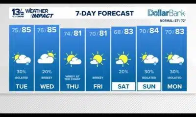
SUMMARY: Weather update: Temperatures dropping tonight with a freeze warning in place for parts of the Mississippi Gulf Coast. People are advised to protect plants, pipes, pets, and themselves, as temperatures could turn colder than forecasted. Calm winds and clear skies are contributing to radiational cooling overnight. The high pressure system will bring calm and clear weather tomorrow but will move on, allowing for clouds and eventual rainfall and thunderstorms on Thursday night and into Friday. The potential for showers and storms is increasing in parts of Louisiana and Southern Arkansas before moving into the forecasted region.
Tuesday November 28th, 2023: Temperatures will likely drop like a rock this evening and then a steady slow drop through the night, especially in the drainage areas along the Pearl and Pascagoula Rivers as well as portions of the west bank especially near Belle Chasse. There is a big potential for temperatures to get much colder than what we are currently showing and some upper 20s are likely tonight but with no guidance hitting the cold hard tonight and then NBM as it usually is on the warm side.


SUMMARY: Former U.S. Senator Trent Lott, reflecting 20 years after Hurricane Katrina, recalled the days leading up to the storm and the extensive recovery efforts that followed. Back in his hometown of Pascagoula, Lott described the lasting impact Katrina had on the community. He emphasized the unparalleled devastation of losing everything and highlighted the remarkable ability of neighbors to come together and help one another. Lott shared a personal memory of working in his yard clearing debris when someone brought him a hot lunch in a Styrofoam container—the best meal he ever had. He was in town as a special guest speaker.
Former Senator Lott reflects on Hurricane Katrina 20 years later
For more Local News from WLOX: https://www.wlox.com/
For more YouTube Content: https://www.youtube.com/channel/UCQZgBHlQMqHUV_hf4_9jLLQ
SUMMARY: Next week, students and staff at Waveland Elementary and North Bay Elementary will celebrate being named Emerging Science of Reading Schools by the Mississippi Department of Education. These two schools are among seven statewide to receive the designation this year. The award recognizes schools that demonstrate a strong focus on implementing the science of reading principles in their teaching. This designation highlights their commitment to improving reading instruction and literacy outcomes for students. The celebrations will honor the achievements of the schools in advancing effective reading strategies in South Mississippi.
MDE gives the designation to schools that focus on building skillful, strong readers in Kindergarten through third grade.
For more Local News from WLOX: https://www.wlox.com/
For more YouTube Content: https://www.youtube.com/channel/UCQZgBHlQMqHUV_hf4_9jLLQ
Local News Video
Mississippi Power donates $350,000 to United Way for customer bill relief amid extreme temperatur…
SUMMARY: Mississippi Power has donated $350,000 to United Way to assist customers facing high energy bills due to air conditioning units running overtime amid extreme temperatures. The increased use of A-C units has driven up power bills, impacting household budgets. Customers within Mississippi Power’s 23-county service territory who need help managing their energy costs are eligible to apply for assistance. Kaila Moran-Griffith emphasized the toll of nonstop A-C use on energy usage and household finances. Those seeking support can contact Catholic Charities to apply for relief and manage their energy expenses during this challenging period.
The Mississippi Power Foundation is donating $350,000 to United Way to help customers with their energy bills.
For more Local News from WLOX: https://www.wlox.com/
For more YouTube Content: https://www.youtube.com/channel/UCQZgBHlQMqHUV_hf4_9jLLQ

US troops won’t be sent to help defend Ukraine, Trump says

Erin: Coastal flooding at high tides forecast in Carolinas, Virginia | North Carolina

Think tank, election attorney support Trump’s vow to end mail-in voting | National

Texas bills restricting trans people have evolved since 2015

This superintendent took a failing Delta school district to a ‘B’ rating. Now, she’s leaving

Trump administration vows to ‘come after’ sanctuary states and cities, despite court setbacks

NATO defense chiefs hold virtual meeting on Ukraine security guarantees

Olympia Café supporters calling on government to help stop possible closure

Tennessee lawmakers respond to Trump’s push to eliminate mail-in ballots

Nelson County woman admits to attempting to kill boyfriend, mother in fire

Kratom poisoning calls climb in Texas

GRAPHIC VIDEO WARNING: Man shot several times at point-blank range outside Memphis convenience store

New Texas laws go into effect as school year starts

Floridians lose tens of millions to romance scams

Unsealed warrant reveals IRS claims of millions in unreported sales at Central Kentucky restaurants

Idaho is losing OB-GYNs. Doctors who remain are trying to shoulder the extra burdens.

Leavenworth mother found guilty in death of 1-year-old daughter

‘They don’t care:’ Advocates for miners with black lung worry as silica dust rule delayed again

‘Get a life,’ Sen. Roger Wicker says of constituents

Cold case murder solved: Nicole Alston’s murder | FOX 5 News

Religious exemption debate front and center amid new school year in WV

Lady Houdini at the Kentucky State Fair

Low 80s and winds possible from Hurricane Erin

First woman to skateboard across the country arrives in Virginia

Push to eliminate sugar from SNAP plan

NBC 10 News Today: ULM Campus Activities Board Week of Welcome

Hurricane Katrina: Mississippi Coliseum served as shelter for storm victims

The Garden Sheddy is ready and open for business in Fayette County

Hurricane Erin latest track and impacts expected along East Coast

A bit cooler Monday with highs in low to mid 80s
-

 News from the South - Texas News Feed5 days ago
Kratom poisoning calls climb in Texas
-
News from the South - Tennessee News Feed5 days ago
GRAPHIC VIDEO WARNING: Man shot several times at point-blank range outside Memphis convenience store
-
News from the South - Texas News Feed2 days ago
New Texas laws go into effect as school year starts
-
News from the South - Florida News Feed2 days ago
Floridians lose tens of millions to romance scams
-
News from the South - Kentucky News Feed5 days ago
Unsealed warrant reveals IRS claims of millions in unreported sales at Central Kentucky restaurants
-

 News from the South - Arkansas News Feed7 days ago
Idaho is losing OB-GYNs. Doctors who remain are trying to shoulder the extra burdens.
-
News from the South - Missouri News Feed7 days ago
Leavenworth mother found guilty in death of 1-year-old daughter
-
News from the South - West Virginia News Feed6 days ago
‘They don’t care:’ Advocates for miners with black lung worry as silica dust rule delayed again