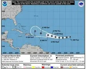
(The Center Square) – Major hurricane status, with wind speeds greater than 110 mph, is expected by Saturday morning just north of the Dominican Republic as Tropical Storm Erin on Tuesday churned across the Atlantic Ocean toward the United States.
The National Hurricane Center, an arm of the National Oceanic and Atmospheric Administration, said it is too early to know the impacts of Erin on the northern Leeward Islands, Virgin Islands and Puerto Rico. Erin was described in an 11 a.m. Eastern update as “moving quickly westward” at 23 mph, at that point about 820 miles west of the Cabo Verde Islands and 1,765 miles east of the Northern Leewards.
Erin is projected to become a hurricane on Thursday, meaning wind speeds of 74-95 mph on the Saffir-Simpson Hurricane Wind Scale. Overnight Friday into Saturday, it would leave the Category 2 range of 96-110 mph and reach Category 3, or major, of 111-129 mph.
Along the southeastern coastline of America, preparations have begun for potential arrival next week. Where is a guess, with the cone of probability still far from Florida.
AccuWeather’s forecasting cone keeps the storm off the coast at least through Tuesday with a turn to the north avoiding the Deep South.
Rough surf and rip currents, however, are likely by the weekend and into early next week regardless of potential landfall.
The Atlantic hurricane season opened June 1 and runs to Nov. 30. Average formation date for the season’s first is Aug. 11.
Last year, three hurricanes in 66 days landed in Florida. The season’s worst damage was from one of them, Helene, that landed near Dekle Beach, Fla., on Sept. 26 and traveled into western North Carolina on Sept. 27. Helene was a Category 4 upon arrival with maximum sustained winds of 140 mph.
The Tarheel State is in its 46th week of recovery from the storm that killed 107 and did an estimated $60 billion damage. Across seven states, Helene killed 236.


