Local News Video
FIRST ALERT: More storms possible Monday (06/08/2025)
SUMMARY: South Mississippi experienced scattered heavy rain and a severe thunderstorm with hail in Stone County, while other areas stayed dry. Heat and humidity remain high, with heat indices near 100°F. Overnight may bring isolated showers, but rain chances stay low Monday morning. Showers and strong thunderstorms are expected to increase Monday afternoon and evening, driven by a cold front and storm systems moving from Texas and Oklahoma. The main threats are gusty winds, large hail, and localized heavy rain; tornado risk is low. This hot, humid, stormy pattern will continue through the week with daily chances of scattered showers and storms.
Meteorologist Taylor Graham explains how more rain could be in the cards for South Mississippi.


SUMMARY: Welcome back, South Mississippi! It’s Weather Kid Wednesday at WXXV, where local kids help with the forecast. Today’s guest is James, an 11-year-old birthday boy who recently celebrated at Escape Arcade. We’re seeing cloud cover and showers mixed with heat. The high today is 97°F, but with humidity, it feels like 115°F due to the heat index—meaning it feels hotter because sweat doesn’t evaporate well. Tomorrow, temperatures will cool slightly to around 103°F with more rain expected, thanks to a low-pressure system. James advises staying in air conditioning, seeking shade, or visiting a water park to beat the heat.
SUMMARY: In the July 22, 2025 game between the Trash Pandas and Shuckers, the Shuckers secured a 5-2 victory to open their six-game homestand. The Shuckers’ pitching was strong, recording seven strikeouts through four innings. Offensively, Bladimir Restituyo drove in the first run on a deep hit down the left field line, allowing Darien Miller to score for a 1-0 lead. Following that, Luis Lara hit a deep single to center field, bringing Jheremy Vargas home from third and extending the lead to 2-0. The Shuckers maintained their advantage and will return home tomorrow for the next game at 6:35 p.m.
Behind 11 walks, seven hits and 7 K’s through four innings from starter Alexander Cornielle, the Shuckers took game one of the six-game homestand.
For more Local News from WLOX: https://www.wlox.com/
For more YouTube Content: https://www.youtube.com/channel/UCQZgBHlQMqHUV_hf4_9jLLQ
Local News Video
FIRST ALERT: Scattered showers and storms possible, hot temperatures continue throughout the week
SUMMARY: FIRST ALERT: Scattered showers and storms are possible today in South Mississippi, with highs near 90°F and heat index values reaching 105°F or higher. Morning showers in Jackson County are dissipating, but a few scattered storms may develop through midday, especially near coastal areas. Rain chances decrease into the evening and over the weekend, with Sunday bringing lower rain chances but higher humidity and temperatures in the low to mid-90s. Heat index values could reach 110–115°F early next week. A tropical air mass remains nearby, potentially increasing rain chances midweek. The tropics show low development risk currently, with the season near normal activity.
Meteorologist Aaron Colby has the latest on possible scattered showers and storms with hot temperatures sticking around.

Dangerous heat wave continues | VIPIR 6 ALERT DAYS Sunday & Monday

Saints Justin Reid says he is focused on leadership role

Death investigator saves life of person wrongly believed to be dead in Knoxville

Chuck E. Cheese employee arrested in iconic mouse mask for stolen credit card

“This can happen to anyone” Gabby Petito's mother speaks on domestic violence awareness

Flood victims wait for damage totals to know how much help they will get

Southwest Airlines flight headed to Las Vegas takes dramatic plunge in response to nearby aircraft

David Nabarro, British physician who led UN response to Ebola and COVID-19, dies

Johnson criticizes Paxton's handling of DREAM Act, calls redistricting 'un-American'

Acorn Plum Galls – Part of a Bigger Story

Helene devastated our region. Even more death and despair might be on the way. • Asheville Watchdog

Law blocks Planned Parenthood from Medicaid dollars, one third of WV patients affected

Appeals court upholds Texas law limiting cities’ ordinances

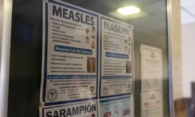
Texas health officials analyze lessons of measles outbreak

Still awaiting a budget in North Carolina, Pennsylvania, Oregon | North Carolina

Mississippi’s U.S. Rep. Michael Guest in running for Homeland Security chair

The scoop on Missouri’s ice cream preferences, according to Instacart

Georgia conservationists push to ‘finish the job’ of protecting Okefenokee from mining

Tech company CEO resigns after controversy over video captured at Coldplay concert

Texas Senate committee doubles down on THC ban
Saints Justin Reid says he is focused on leadership role
“This can happen to anyone” Gabby Petito's mother speaks on domestic violence awareness
Flood victims wait for damage totals to know how much help they will get

Heat Advisory: Feels-like temps topping 105° this weekend

SC veteran, dog aid Texas search efforts after floods

Logan County landowners frustrated after second pipeline spill in several months contaminates proper

4-year-old with rare birthmark meets anime ‘twin’ after viral TikTok

Neighbor yelled homophobic slurs before brutally beating 22-year-old CNA, loved ones say

WDSU investigates the other times inmates have been mistakenly released from OJC

Troup County man charged in deadly dog attack | FOX 5 News
-

 News from the South - North Carolina News Feed6 days ago
Helene devastated our region. Even more death and despair might be on the way. • Asheville Watchdog
-
News from the South - West Virginia News Feed3 days ago
Law blocks Planned Parenthood from Medicaid dollars, one third of WV patients affected
-
News from the South - Texas News Feed7 days ago
Appeals court upholds Texas law limiting cities’ ordinances
-
News from the South - Texas News Feed6 days ago
Texas health officials analyze lessons of measles outbreak
-
News from the South - Missouri News Feed7 days ago
The scoop on Missouri’s ice cream preferences, according to Instacart
-
 News from the South - North Carolina News Feed6 days ago
Still awaiting a budget in North Carolina, Pennsylvania, Oregon | North Carolina
-
Mississippi Today6 days ago
Mississippi’s U.S. Rep. Michael Guest in running for Homeland Security chair
-
News from the South - Georgia News Feed6 days ago
Georgia conservationists push to ‘finish the job’ of protecting Okefenokee from mining