Local News Video
FIRST ALERT: Freezing temps tonight, wet & windy Friday ahead (01/08/2025)
SUMMARY: Chief Meteorologist Eric Jeansonne provided an update on the cold weather in South Mississippi, with no significant warm-up expected. The region will experience chilly temperatures and a stormy Friday, with potential for heavy rain, gusty winds, and icy conditions in the north. Tonight, temperatures are expected to drop into the upper 20s, so it’s important to protect plants and pets. While the Gulf Coast won’t likely see wintry weather, northern areas may experience snow and ice. The storm system will bring rain to the area late Thursday into Friday morning, affecting commutes. The cold weather will persist into next week.
Chief Meteorologist Eric Jeansonne brings the latest on freezing temperatures across the Coast and how the Friday commute could be a wet one.


SUMMARY: South Mississippi will start the week with scattered showers and thunderstorms, especially Monday and Tuesday, with 1-2 inches of rain possible. Temperatures remain hot and humid, mostly in the upper 80s to low 90s. A cold front will bring more rain chances before a high-pressure ridge builds midweek, lowering rain chances by Wednesday through Friday. The Fourth of July looks mostly dry but very hot, with highs possibly in the mid to upper 90s and heat indices above 100. A low-pressure area near the Gulf or East Coast could develop into a tropical system by next weekend, bringing heavy rain, but details remain uncertain.
Meteorologist Taylor Graham explains how a soggy start to the week could be in the cards for South Mississippi.
Local News Video
Tropical Depression Two nearing coast of Mexico, low development chance in the Northeast Gulf
SUMMARY: Tropical Depression Two is nearing the coast of Mexico, expected to make landfall within 12 to 24 hours, with a brief chance of strengthening into Tropical Storm Barry. It remains disorganized and weak, likely to dissipate quickly after landfall. Meanwhile, South Mississippi is experiencing a rainy Sunday morning with showers and storms moving onshore, accompanied by hot temperatures and heat indices near 100-105°F. Afternoon and evening storms may bring gusty winds and lightning. A front drifting offshore in the northeastern Gulf could bring tropical development in the next 5-7 days but poses no immediate threat to the area. Rain chances remain high into the week.
Meteorologist Aaron Colby has the latest details on Tropical Depression Two, which is nearing the coast of Mexico.
SUMMARY: South Mississippi will experience scattered showers and thunderstorms over the next few days, especially from late morning to early afternoon, with some storms potentially producing heavy rain and isolated flooding. Temperatures will remain hot and humid, mostly in the upper 80s to low 90s. Rain chances may lessen slightly by Thursday and Friday, but hit-or-miss storms are still possible during the Fourth of July holiday. A new tropical depression formed in the southern Gulf of Mexico, expected to strengthen briefly before making landfall in Mexico, posing no threat to South Mississippi. Residents should stay alert as the hurricane season progresses.
Meteorologist Taylor Graham gives this week’s expected forecast and the latest update oin tropical development.

Kenyan civilian shot at close range by police during protests dies

US Senate launches debate on GOP mega-bill, but passage still not assured

Nashville’s home listings are outpacing closings, new report shows

Florida weather-control ban takes effect this week. Here’s what that means

Gunman started Idaho blaze and then fatally shot 2 firefighters in ambush attack, officials say

Senate continues debating Trump’s “Big Beautiful Bill”

Local Party Leaders Response to Trump's Bill

Yes, the chance of rain is a true percentage of when you might see rain

FIRST ALERT: Rain expected to kick off the week (06/29/2025)

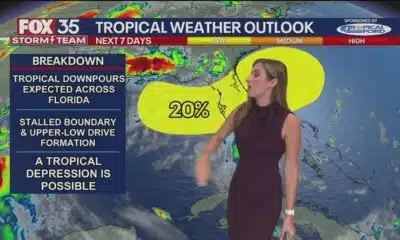
Tropics update: Will tropical disturbance form over Florida by July 4?

Thieves take thousands of dollars in equipment from Union County Soccer League

Defendant in auditor’s ‘second largest’ embezzlement case in history goes free

Robert Nichols to retire from Texas Senate

3 lawsuits filed against CVS, Louisiana AG announces

ACLU, student group to sue Texas over expansive 'parental rights' bill

Residents provide feedback in Kearney Street Corridor redevelopment meeting

News 5 NOW at 12:30pm | June 24, 2025

New Spring Hill hotel would replace former armory

The Rio Grande Valley as Heart of LGBTQ+ Resistance and Joy

What Texas lawmakers did this session to close workforce gaps
Senate continues debating Trump’s “Big Beautiful Bill”
Local Party Leaders Response to Trump's Bill
Yes, the chance of rain is a true percentage of when you might see rain
FIRST ALERT: Rain expected to kick off the week (06/29/2025)
Tropics update: Will tropical disturbance form over Florida by July 4?

Sen. Thom Tillis won’t run for reelection after Trump primary threat

One killed, three injured in shooting at southeast Atlanta park

Alligator Alcatraz: What we know | FOX 5 News

Thousands celebrate pride, progress at the 2025 NWA Pride Parade

Tropical Depression Two nearing coast of Mexico, low development chance in the Northeast Gulf
-

 News from the South - Tennessee News Feed6 days ago
Thieves take thousands of dollars in equipment from Union County Soccer League
-
Mississippi Today4 days ago
Defendant in auditor’s ‘second largest’ embezzlement case in history goes free
-
News from the South - Texas News Feed6 days ago
Robert Nichols to retire from Texas Senate
-
News from the South - Louisiana News Feed6 days ago
3 lawsuits filed against CVS, Louisiana AG announces
-
News from the South - Texas News Feed7 days ago
ACLU, student group to sue Texas over expansive 'parental rights' bill
-
News from the South - Missouri News Feed5 days ago
Residents provide feedback in Kearney Street Corridor redevelopment meeting
-
News from the South - Alabama News Feed6 days ago
News 5 NOW at 12:30pm | June 24, 2025
-
News from the South - Alabama News Feed7 days ago
New Spring Hill hotel would replace former armory