Local News Video
DIGITAL DESK: Cold temps and a look at rain ahead
SUMMARY: In this Friday update, Senior Meteorologist Wesley Williams reports on cold weather in South Mississippi, with wind chills in the 20s and 30s. The morning featured freezing temperatures and brisk north winds, particularly along the coast. Though temperatures are expected to reach 54°F today and 61°F tomorrow, the weekend will warm to the low 70s, with some rain possible. Next week, heavy rain and potential flooding are expected, especially on Monday and Tuesday, with the risk of over three inches of rain. The weather will dry and cool by Wednesday, with temperatures dropping into the 50s.
Senior Meteorologist Wesley Williams has a look at CHILLY temps Friday morning and potential rain in the forecast ahead.


SUMMARY: Sparklight is helping Coast families with back-to-school costs by giving out 400 backpacks filled with essential school supplies. Starting today, 100 of these backpacks will be available at four locations in Biloxi, Gulfport, Long Beach, and Pascagoula. The backpacks and supplies are being distributed on a first-come, first-serve basis, with one backpack allowed per family. The event included food, fellowship, and fun activities for kids, such as bounce houses, creating a community atmosphere while supporting local students and families preparing for the new school year.
The company is giving out approximately 400 free backpacks filled with essential school supplies.
For more Local News from WLOX: https://www.wlox.com/
For more YouTube Content: https://www.youtube.com/channel/UCQZgBHlQMqHUV_hf4_9jLLQ
SUMMARY: Good evening, South Mississippi. Meteorologist Hither Grim reports typical summer weather this weekend: hot, humid, with scattered showers and storms. Some spots, like Gulfport and north of I-10, saw 2-3 inches of rain, providing temporary relief. Overnight rain chances remain low, with Sunday morning mostly dry—good for outdoor activities or church. A weak boundary along the coast and a low-pressure area will maintain daily, hit-or-miss showers and storms through midweek. Temperatures will be in the upper 80s to low 90s, near average. No Gulf Coast tropical threats now, but two Atlantic systems are being monitored, with more activity expected later in August and September.
Meteorologist Taylor Graham gives what to expect from the Tropics and upcoming weather this weekend.
Local News Video
FIRST ALERT: Scattered showers and storms possible, NHC marks zone off east coast for development
SUMMARY: A cold front has passed offshore South Mississippi and is now stalling, creating elevated chances for scattered showers and storms through Monday, mainly in the afternoons and evenings. Temperatures remain warm, with heat index values possibly reaching triple digits. Rainfall could be heavy in spots, especially east of the region, with some areas potentially receiving 3 to 5 inches. The stalled front may also spawn a low-pressure system, increasing thunderstorm activity. The National Hurricane Center notes a low chance of development off the North Carolina coast, posing no threat to South Mississippi. Tropical activity is expected to increase in the coming months.
Meteorologist Aaron Colby has the latest on Saturday’s potential for scattered showers and storms, and the chance for development off the east coast.

House GOP subpoenas DOJ, Clintons in Epstein probe

Review board recommends no charter for Agape Achievement Academy | North Carolina

Great American Farmers Market
Mississippi College to support Jackson VA with student counselors

Why can’t we just sterilize bears? Or relocate them? What happened to the City of Asheville water report? • Asheville Watchdog

Parents hit back-to-school shopping with eye on Trump tariffs

Medicaid cuts in Trump’s tax and spending law could burden school budgets

Trump administration moves to end veterans’ abortion access in cases of rape, incest and health

🐶 These 10 states have the healthiest dogs

29-year-old killed after driving off road in 'dangerous' section road | FOX 5 News

Rural Texas uses THC for health and economy

Yelp names ‘Top 100 Sandwich Shops’ in the US, several Texas locations make the cut

Harrison County Doctor Sentenced for Unlawful Distribution of Controlled Substances

Released messages show Kerrville officials’ flood response

Residents along Vermilion River want cops to help prevent land loss

Decision to unfreeze migrant education money comes too late for some kids

‘Good government’ group urges blue states to back away from a redistricting arms race

‘Half-baked’ USDA relocation irritates members of both parties on Senate Ag panel

Officer shot, hospitalized after shooting near Busch Gardens

Bookman: Burt Jones’ pledge to eliminate Georgia’s income tax is wrong-headed
Great American Farmers Market
29-year-old killed after driving off road in 'dangerous' section road | FOX 5 News

Drivers experience is ‘worsening’ at NC DMV, state auditor’s report says

Arkansas man who pleaded guilty to killing four people in 2024 mass shooting sentenced to prison

Back-to-School Season in Alabama | Aug. 4, 2025 | News 19 at 6 p.m.

Boeing workers on strike, cite 'unfair' contract

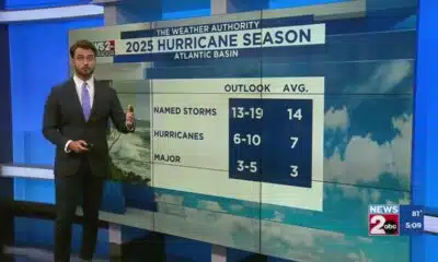
Tracking the tropics: The Atlantic is getting active

Boone St. crossing unsafe to walk across

Back to school shopping tips to save some money

Loni Anderson, 'WKRP in Cincinnati' star, dies just days before 80th birthday
-

 News from the South - Texas News Feed4 days ago
Rural Texas uses THC for health and economy
-
News from the South - Texas News Feed6 days ago
Yelp names ‘Top 100 Sandwich Shops’ in the US, several Texas locations make the cut
-
News from the South - Kentucky News Feed6 days ago
Harrison County Doctor Sentenced for Unlawful Distribution of Controlled Substances
-
News from the South - Texas News Feed6 days ago
Released messages show Kerrville officials’ flood response
-
News from the South - Louisiana News Feed6 days ago
Residents along Vermilion River want cops to help prevent land loss
-
News from the South - Alabama News Feed5 days ago
Decision to unfreeze migrant education money comes too late for some kids
-
News from the South - West Virginia News Feed6 days ago
‘Good government’ group urges blue states to back away from a redistricting arms race
-
News from the South - Louisiana News Feed5 days ago
‘Half-baked’ USDA relocation irritates members of both parties on Senate Ag panel