Local News Video
Car crashes reported across South Mississippi during heavy rain Monday morning
SUMMARY: Heavy rain caused multiple car accidents across South Mississippi on Monday morning, with conditions still wet as the weather began to clear. Noah Noble reported live from Harrison County, mentioning wrecks on Interstate 10 between Long Beach and Ocean Springs, including a sedan off the road and a truck stuck in the median. Police and fire crews responded to several crashes and fires sparked by lightning. One fire occurred after a lightning strike hit a tree. Despite rain, lightning strikes can still ignite fires, so residents are advised to stay cautious and keep fire extinguishers and phones handy.
People across South Mississippi saw heavy rain and lightning on Monday.
For more Local News from WLOX: https://www.wlox.com/
For more YouTube Content: https://www.youtube.com/channel/UCQZgBHlQMqHUV_hf4_9jLLQ


Local News Video
Saints Report: Saints lose another close game this time in week two against the San Francisco 49ers
SUMMARY: The New Orleans Saints lost a close game in week two against the San Francisco 49ers, 26-21, at the Caesar Superdome. Despite missing key 49ers players, the Saints struggled early but fought back with touchdowns by Rasheed Shahid and Devon Ble. A critical fourth-down sack of Spencer Rattler sealed their fate. Coach Kell Moore praised the team’s effort but emphasized the need for better situational play and seizing opportunities. The Saints aim to improve as they prepare to face the Seattle Seahawks next Sunday, September 21st. Reporting from the Caesar Superdome, Ever Gier Jr., WXXV News25 Sports.
SUMMARY: Harrison County leaders have finalized and approved the 2025-2026 fiscal budget with no tax increase, balancing expenditures at around $324 million. The Board of Supervisors completed budget talks and passed the budget before the October 1st deadline. Board President Nathan Barrett confirmed there will be no increases in the county’s tax levies. However, the Harrison County School District will implement a small, state-required increase in their school tax, which is a formality and expected to have minimal impact on taxpayers. Overall, the county’s budget remains stable without additional fiscal burdens on residents.
The Board of Supervisors passed the 2025-2026 fiscal budget on Monday. For more Local News from WLOX: …
SUMMARY: For Week 3 of the WXXV Game of the Week, Everett Gier Jr. previews the matchup between Pascagoula and Ocean Springs. Coach Lewis, whose team won the Game of the Week vote, expressed pride in the recognition. Coming off a tough loss to Biloxi, the team is focused on fixing mistakes and executing well. Key players to watch include Jason Glaw, running backs, offensive linemen Thomas Ash and Tyler Scoon, and receivers Darius Carter, DJ Nunnery, and Learian Picket. The WXXV sports department will be covering the game live, eager to see a strong performance from Pascagoula.
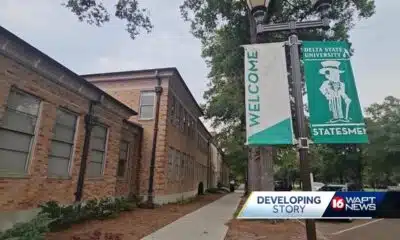
Rep. Bennie Thompson calling on federal investigation into Delta State student’s death

A Sanctuary in Goodman: The Magic of the Public Library

Suspect in Charlie Kirk killing is charged with murder as prosecutor says DNA found on rifle trigger

Hyde-Smith, Warnock team up to recognize Gold Star Families Remembrance Week

FDA takes aim at Hims and other telehealth services in drug advertising blitz

Saints Report: Saints lose another close game this time in week two against the San Francisco 49ers

Harrison County approves budget with no tax increase

‘Little quiet light’: Family remembers Delta State University student found dead on campus

Trump says the US should do away with quarterly earnings reports

The Mustard Seed

Lexington man accused of carjacking, firing gun during police chase faces federal firearm charge

Zaxby's Player of the Week: Dylan Jackson, Vigor WR

California mother says daughter killed herself after being transitioned by school | California

Arkansas medical marijuana sales on pace for record year

Local, statewide officials react to Charlie Kirk death after shooting in Utah

William Carey University holds 'tailgates and tourniquets' blood drive

What we know about Charlie Kirk shooting suspect, how he was caught

US stocks inch to more records as inflation slows and Oracle soars

Russian drone incursion in Poland prompts NATO leaders to take stock of bigger threats

Federal hate crime charge sought in Charlotte stabbing | North Carolina
Saints Report: Saints lose another close game this time in week two against the San Francisco 49ers
Harrison County approves budget with no tax increase
‘Little quiet light’: Family remembers Delta State University student found dead on campus
The Mustard Seed

WXXV Game of the Week: Week 3

White House officials hold prayer vigil for Charlie Kirk

Jonesboro band culture responsible for global legacy | FOX 5

Family, friends hold candlelight vigil in honor of Giovanni Pelletier

Manhunt ends with arrest, new charges for alleged child killer | FOX 5 News

A look at recent flooding across South Florida
-

 News from the South - Kentucky News Feed6 days ago
Lexington man accused of carjacking, firing gun during police chase faces federal firearm charge
-
News from the South - Alabama News Feed6 days ago
Zaxby's Player of the Week: Dylan Jackson, Vigor WR
-
 The Center Square7 days ago
California mother says daughter killed herself after being transitioned by school | California
-
News from the South - Arkansas News Feed6 days ago
Arkansas medical marijuana sales on pace for record year
-
Local News Video7 days ago
William Carey University holds 'tailgates and tourniquets' blood drive
-
News from the South - North Carolina News Feed5 days ago
What we know about Charlie Kirk shooting suspect, how he was caught
-
News from the South - Missouri News Feed7 days ago
Local, statewide officials react to Charlie Kirk death after shooting in Utah
-
Local News6 days ago
US stocks inch to more records as inflation slows and Oracle soars