Local News Video
Candidate Conversations: Pascagoula's David Bates
SUMMARY: David Bates, a candidate for Pascagoula mayor, shares his motivation for running, driven by a lifelong commitment to public service and community involvement. Having taught in the Pascagoula School District and served as the city’s athletic director, he aims to be a voice for the community. Bates advocates for further downtown development and enhancing recreational opportunities for youth. He emphasizes an organic campaign approach, focusing on personal connections with residents. Bates plans to engage with the community actively, ensuring that all voices are heard, and expresses his desire to foster growth and engagement within Pascagoula.


SUMMARY: Good evening, South Mississippi. Meteorologist Hither Grim reports typical summer weather this weekend: hot, humid, with scattered showers and storms. Some spots, like Gulfport and north of I-10, saw 2-3 inches of rain, providing temporary relief. Overnight rain chances remain low, with Sunday morning mostly dry—good for outdoor activities or church. A weak boundary along the coast and a low-pressure area will maintain daily, hit-or-miss showers and storms through midweek. Temperatures will be in the upper 80s to low 90s, near average. No Gulf Coast tropical threats now, but two Atlantic systems are being monitored, with more activity expected later in August and September.
Meteorologist Taylor Graham gives what to expect from the Tropics and upcoming weather this weekend.
Local News Video
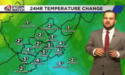
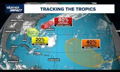
FIRST ALERT: Scattered showers and storms possible, NHC marks zone off east coast for development
SUMMARY: A cold front has passed offshore South Mississippi and is now stalling, creating elevated chances for scattered showers and storms through Monday, mainly in the afternoons and evenings. Temperatures remain warm, with heat index values possibly reaching triple digits. Rainfall could be heavy in spots, especially east of the region, with some areas potentially receiving 3 to 5 inches. The stalled front may also spawn a low-pressure system, increasing thunderstorm activity. The National Hurricane Center notes a low chance of development off the North Carolina coast, posing no threat to South Mississippi. Tropical activity is expected to increase in the coming months.
Meteorologist Aaron Colby has the latest on Saturday’s potential for scattered showers and storms, and the chance for development off the east coast.
SUMMARY: Mostly dry conditions continue Thursday evening across South Mississippi with clear skies and calm marine conditions near the coast. Temperatures range from upper 80s to low 90s inland, with high humidity contributing to heat advisories. Overnight lows will drop to the mid-70s. A few isolated showers may appear mainly near the coastline overnight, but overall it stays dry. Friday will be hotter with highs in the low to mid-90s and scattered storms likely in the afternoon and evening as a cold front approaches from the north. The front will pass Saturday morning, easing rain chances but leaving unsettled weather into next week.

Abbott orders House Democrats to return to Austin or be removed from office | Texas

Christian's Morning Forecast: A Nice Start Before More Showers

Pritzker says Texas Democrats who fled state will be protected amid arrest threats

Georgia lawmakers to return this winter to Capitol chambers refreshed with 19th Century details

Songs of Love writes personalized music for kids — but can AI carry the tune?

Nonprofit hospitals spend millions on stadium naming rights, raising eyebrows

Warning for social media shoppers after $22K RV scam

What do Trump's new tariffs mean for the economy? Experts weigh in

'Papa Rock': Rahaman Ali remembered for his legacy of loyalty and love

Texas edge Ethan Burke is trying to ‘be the best version of himself’ in 2025

Rural Texas uses THC for health and economy

South Carolina man detained by ICE over two years, ‘He is not here illegally’

Berkeley County family sues Delta Airlines over explicit videos taken by employee on stolen iPad

State public health departments fear looming federal cuts in Trump’s next budget

Harrison County Doctor Sentenced for Unlawful Distribution of Controlled Substances

Co-founder of whites-only group speaks on previous homestead stabbing

Yelp names ‘Top 100 Sandwich Shops’ in the US, several Texas locations make the cut

Released messages show Kerrville officials’ flood response

Federal judge issues new order protecting all Planned Parenthood clinics from Medicaid ‘defunding’

Warning for parents: This teen trend can prove deadly | FOX 5 News
Christian's Morning Forecast: A Nice Start Before More Showers
What do Trump's new tariffs mean for the economy? Experts weigh in
'Papa Rock': Rahaman Ali remembered for his legacy of loyalty and love

Boeing union workers in St. Louis area reject new labor agreement, strike imminent

Religious leaders call for change one week after mass shooting | FOX 5 News

Weather Impact: Tracking 3 spots in the tropics

State Rep. Shaundelle Brooks speaks after convicted Antioch Waffle House shooter asks for new trial

Woman, daughter rescued from Georgia Lake after girl slips in | FOX 5 News

Commanders stadium deal passes first DC Council vote | NBC4 Washington

South Florida afternoon showers, storms may help alleviate the heat
-

 News from the South - Texas News Feed3 days ago
Rural Texas uses THC for health and economy
-
News from the South - Georgia News Feed7 days ago
South Carolina man detained by ICE over two years, ‘He is not here illegally’
-
News from the South - Georgia News Feed6 days ago
Berkeley County family sues Delta Airlines over explicit videos taken by employee on stolen iPad
-
News from the South - Alabama News Feed7 days ago
State public health departments fear looming federal cuts in Trump’s next budget
-
News from the South - Kentucky News Feed5 days ago
Harrison County Doctor Sentenced for Unlawful Distribution of Controlled Substances
-
News from the South - Missouri News Feed6 days ago
Co-founder of whites-only group speaks on previous homestead stabbing
-
News from the South - Texas News Feed5 days ago
Released messages show Kerrville officials’ flood response
-
News from the South - Texas News Feed5 days ago
Yelp names ‘Top 100 Sandwich Shops’ in the US, several Texas locations make the cut