Local News Video
9/2 – Trey Tonnessen's “Labor Night” Monday Night Forecast
SUMMARY: Labor Day weather is warm and humid, with feels-like temperatures reaching the upper 80s to 90s. As many prepare to return to work, the forecast indicates that this heat and humidity will persist, although a slight relief could arrive later. Widespread thunderstorms are expected this week due to a stalled frontal system influenced by a trough to the north. The National Hurricane Center has highlighted three areas of concern in the tropics, but the immediate forecast primarily involves showers and storms. Temperatures currently range from the upper 70s to mid-80s, signaling a transition towards fall is still approaching.
9/2 – Trey Tonnessen’s “Labor Night” Monday Night Forecast


Local News Video
15-minute parking spots added in downtown Gulfport to ease congestion during renovations
SUMMARY: In Gulfport, eight temporary 15-minute parking spots are being added near the Hancock Whitney Bank to reduce congestion during upcoming renovations. The bank building, located across Highway 49, is set to be renovated, though no official start date has been determined. City leaders hope these short-term parking spots will ease traffic by accommodating customers using the bank’s drive-thru, where parking is currently limited, especially at peak times. These spots will remain in place until the renovation work is finished, improving access for customers to enter and exit quickly while construction occurs in downtown Gulfport.
Eight 15-minute parking spots will be temporarily added at the Hancock Whitney Bank in Gulfport. For more Local News from …
SUMMARY: The Mississippi Department of Education is hosting a series of statewide literacy meetings this month to improve reading skills and family engagement. One meeting took place at Reeves Elementary in Long Beach, aiming to review Mississippi’s Literacy-Based Promotion Act, a 2013 state law promoting comprehensive reading instruction for children. The department and Long Beach School District emphasize the importance of involving families in this process, as a solid literacy foundation benefits children’s lifelong learning and fluency. These meetings provide an opportunity to equip parents with effective tools to support their children’s literacy development and overall success in education and life.
The Mississippi Department of Education is hosting a series of literacy meetings across the state this month.
For more Local News from WLOX: https://www.wlox.com/
For more YouTube Content: https://www.youtube.com/channel/UCQZgBHlQMqHUV_hf4_9jLLQ
SUMMARY: Destiny, an adorable 11-week-old tabby calico kitten, is this week’s Pet of the Week from the Jackson County Animal Shelter. She’s litter box trained, good with everything, and almost ready to be fixed, with spaying included in the adoption fee. The shelter currently has around 80 cats and kittens available and is overcrowded, needing donations of Purina cat chow, kitten chow, canned cat food, and dog food. Adoption is easy and affordable, with cats available for no fee and kittens for $25. The shelter is open Monday to Friday, 10 a.m. to 4 p.m., and Saturdays, 10 a.m. to 2 p.m.

A mysterious envelope from Czechoslovakia’s founding father has been found

Charlie Kirk memorial service: Trump, supporters to pay tribute in Arizona

The oldest mummies in the world may hail from southeastern Asia and date back 12,000 years

A Slug’s Life – Slow and Steady

Who qualifies for ‘no tax on tips’ and what counts as a tip? Here are the new rules
Prosecutor says stalking suspect ambushed Pennsylvania police officers, killing 3

Pops in the Park Returns October 7

Biloxi Shuckers eliminated from 2025 playoffs by Montgomery

Morning ‘Sip: Red Carpet Bowl

Events happening this weekend in Mississippi: September 19-21

DNA evidence found near scene of Charlie Kirk’s shooting matches suspect, FBI director says

Orlando restaurant owner invites artists to parking lot amid federal fight against street art

Family of Curious George Creators to Visit de Grummond in Hattiesburg

The Mustard Seed

Hyde-Smith, Warnock team up to recognize Gold Star Families Remembrance Week

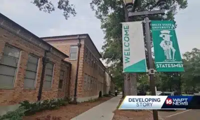
‘Little quiet light’: Family remembers Delta State University student found dead on campus

White House officials hold prayer vigil for Charlie Kirk

FDA takes aim at Hims and other telehealth services in drug advertising blitz

Frustrated with poor play against UTEP, Arch Manning will 'get back to basics'

Mobile opioid addiction treatment in Tennessee requires workarounds, for now
Morning ‘Sip: Red Carpet Bowl

15-minute parking spots added in downtown Gulfport to ease congestion during renovations

Family of Delta State student found hanging seeks answers

Statewide literacy meetings aim to boost reading skills and family engagement

Pet of the Week: Destiny is looking for a forever home!

Saints Report: Saints lose another close game this time in week two against the San Francisco 49ers

Harrison County approves budget with no tax increase
‘Little quiet light’: Family remembers Delta State University student found dead on campus
The Mustard Seed

WXXV Game of the Week: Week 3
-

 Local News6 days ago
DNA evidence found near scene of Charlie Kirk’s shooting matches suspect, FBI director says
-
News from the South - Florida News Feed7 days ago
Orlando restaurant owner invites artists to parking lot amid federal fight against street art
-
Our Mississippi Home6 days ago
Family of Curious George Creators to Visit de Grummond in Hattiesburg
-
Mississippi News Video6 days ago
The Mustard Seed
-
SuperTalk FM5 days ago
Hyde-Smith, Warnock team up to recognize Gold Star Families Remembrance Week
-
Mississippi News Video6 days ago
‘Little quiet light’: Family remembers Delta State University student found dead on campus
-
News from the South - North Carolina News Feed7 days ago
White House officials hold prayer vigil for Charlie Kirk
-
Local News5 days ago
FDA takes aim at Hims and other telehealth services in drug advertising blitz