Local News Video
5/27 – Sam Parker’s “Storms for Lunch” Tuesday Morning Forecast
SUMMARY: South Mississippi is under a severe thunderstorm watch until 1:00 p.m., with storms currently affecting eastern Louisiana and parts of northern Mississippi. Strong winds, flash flooding, and possible hail or tornadoes are concerns, especially north of Interstate 10. Showers and thunderstorms are expected around lunchtime, with scattered showers continuing into the evening. A stationary front will bring more scattered storms Wednesday and Thursday, keeping rain chances high through the week. Temperatures are warm and muggy, with highs near 87 degrees today. A cool front will arrive Saturday, bringing clearer skies and lower humidity.


SUMMARY: South Mississippi begins Friday reflecting on Hurricane Katrina’s 20th anniversary, which struck on August 29, 2005, causing lasting damage compared to the 2004 Indian tsunami. Meteorologist Ryan reminds viewers to learn from past lessons and stay prepared as tropical activity remains low but a 30% chance of development is possible mid-next week off Africa’s west coast due to weakening dry air. Today is gray and cool with light to moderate showers, including heavy rain in Hancock County surpassing six inches in 24 hours, causing flooding. Rain will continue into Friday night, tapering off through the weekend with sunnier skies returning Sunday.
SUMMARY: Sam Lucey’s “Partly Cloudy and Comfortable” Wednesday evening forecast shows a mix of blue sky, sunshine, and incoming clouds this afternoon. Mississippi Power Radar remains dry with temperatures in the mid to upper 80s, slightly warmer inland. Northeasterly winds tonight will bring drier air, easing humidity. Tomorrow, expect highs near 89°F with increasing cloud cover and a chance of showers or storms, especially inland, due to an approaching warm front. Rain chances rise Friday as the front moves through, with temperatures steady in the upper 80s to mid-80s through the weekend and early next week as skies gradually clear.
Local News Video
Experts in marine science, technology gather in Biloxi for Oceans in Action workshop
SUMMARY: Experts in marine science and technology gathered at the Mississippi Coast Convention Center in Biloxi for the three-day Oceans in Action workshop. The event brings together professionals from industry, academia, and government across the Gulf Coast to collaborate, share knowledge, and showcase projects. Day one featured a panel on environmental DNA and presentations from state agencies and universities. The workshop aims to foster partnerships that drive innovation in marine science and technology, promoting progress in the blue economy. Organizers emphasize the importance of connecting diverse sectors to push boundaries and advance ocean research. The workshop continues through Thursday.

Hackett student arrested after shooting threat

Delray Beach leaders fight for rainbow street mural during Florida hearing in Orange County

Third set of twins for St. Louis area mom: 8 kids total

By the numbers: Stats to know about the Texas Longhorns' 2025 season

Rudy Giuliani leaves the hospital after being injured in a car crash in New Hampshire

Council to finalize Lemoine Building purchase, Northside rezoning

Pre-Fall Fun in Mississippi | Our Mississippi Home

Christian's Morning Forecast: Nice Day Before Storms Ahead

In NC, Black communities meet mental health needs of youth in barbershops and churches

Monroe County Football Coach speaks out, calls for more support for team

DEI, campus culture wars spark early battle between likely GOP rivals for governor in Mississippi

Judge: Felony disenfranchisement a factor in ruling on Mississippi Supreme Court districts

Parasocial party: Why people are excited for the Taylor Swift, Travis Kelce engagement

K+20: Katrina alters local health care landscape, though underlying ills still the same

Parents of missing 7-month-old California boy are charged with murder

The Great Backyard Recovery – Helping Birds After the Storm

08/29 Ryan's “Wet End to the Week” Friday Forecast

Man who shot ex-girlfriend died after shootout with deputies at apartment complex, MDSO says

Police say Minneapolis church shooter was filled with hatred and admired mass killers

U-M Health ends transgender treatment for minors | Michigan
Hackett student arrested after shooting threat
Christian's Morning Forecast: Nice Day Before Storms Ahead
Monroe County Football Coach speaks out, calls for more support for team

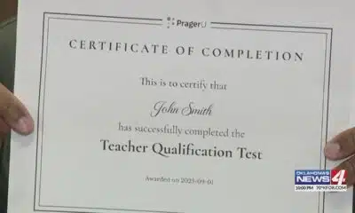
Test taker finds it's impossible to fail 'woke' teacher assessment

Biologists are using drones to scare wolves away from cattle

Schools navigate challenges in federal clean bus program | FOX 5 News

Dunn paramedic recovering from head-on crash

Alabama Lawmakers Threaten to Dismantle Athletic Association After New Rule | Sept. 1, 2025 | News 1

LIVE: Tropical weather update

35,000 attendees visit Paint Louis over 4-day run
-

 Mississippi Today3 days ago
DEI, campus culture wars spark early battle between likely GOP rivals for governor in Mississippi
-
Mississippi Today7 days ago
Judge: Felony disenfranchisement a factor in ruling on Mississippi Supreme Court districts
-
News from the South - North Carolina News Feed5 days ago
Parasocial party: Why people are excited for the Taylor Swift, Travis Kelce engagement
-
News from the South - Louisiana News Feed6 days ago
K+20: Katrina alters local health care landscape, though underlying ills still the same
-
Local News7 days ago
Parents of missing 7-month-old California boy are charged with murder
-
Our Mississippi Home6 days ago
The Great Backyard Recovery – Helping Birds After the Storm
-
Local News5 days ago
Police say Minneapolis church shooter was filled with hatred and admired mass killers
-
 The Center Square6 days ago
U-M Health ends transgender treatment for minors | Michigan