Local News Video
11/18 – Sam Parker's “Pack the Poncho” Monday Night Forecast
SUMMARY: Sam discusses the anticipation of rain in the area, with current light showers in parts of Pearl River and Hancock Counties. Flood watches are active until noon Tuesday due to expected heavier rainfall from the remnants of a system moving northeast. Morning lows will range from the mid-60s to mid-70s, with temperatures slightly warming up during the day. A cold front is expected to arrive Wednesday, bringing a significant drop in temperatures and additional rainfall, potentially 2-6 inches total. Overall, cooler weather is anticipated for the upcoming days, especially in the low 40s.


Local News Video
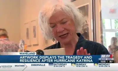
Local artist, Kat Fitzpatrick, breaks down her experience of Hurricane Katrina through her artwor…
SUMMARY: Local artist Kat Fitzpatrick reflects on her Hurricane Katrina experience through a five-act watercolor series at the Silver Lining exhibit in Studio Waveland. After Katrina destroyed her Bay St. Louis home, Fitzpatrick used 300 lb watercolor paper to depict the tragedy. The first act shows the 32-foot flood resembling a Hokusai wave; the second symbolizes hope; the third portrays chaos during her search for her mother; the fourth depicts debris and loss, including a horse; and the final act reveals the past community beneath rebuilt Bay St. Louis. Her art expresses tragedy, community, and resilience two decades later.
Local artist, Kat Fitzpatrick, breaks down her experience of Hurricane Katrina through her artwork
For more Local News from WLOX: https://www.wlox.com/
For more YouTube Content: https://www.youtube.com/channel/UCQZgBHlQMqHUV_hf4_9jLLQ
SUMMARY: South Mississippi’s Thursday forecast calls for near-normal temperatures with fewer showers than recent days. Tropical activity includes Tropical Storm Dexter with 50 mph winds, a weakening system off the East Coast with a 30% development chance, and another disturbance in the central Atlantic that could become the next named storm. Locally, calm seas and mostly clear skies are expected, with isolated afternoon coastal showers and thunderstorms possible. Friday should be drier, but rain chances rise again over the weekend and early next week due to a low south of the area. Increased rain next week will slightly cool temperatures.
SUMMARY: South Mississippi faces a hot, humid Thursday with afternoon storms possible. Thunderstorms are developing mainly over Stone and George counties but may weaken as daytime heating fades. Rain chances tonight are low but not zero. Tomorrow mirrors today with coastal showers and scattered afternoon storms, temperatures near 90°F, and heat indices reaching 105°F where storms are absent. Offshore winds will be light, with variable gusts near storms. Water temps are in the upper 80s. No Gulf tropical threats currently, but the Atlantic’s tropical wave Invest 96L is being watched for gradual development. The 7-day forecast calls for ongoing hot, humid weather with scattered storms.
Chief Meteorologist Eric Jeansonne explains why typical South Mississippi weather is to be expected along with why storms can’t be ruled out.

What could a street art program look like in Lexington?

Summer’s best meteor shower peaks soon. But the moon will interfere with viewing the Perseids

CDC shooter blamed COVID vaccine for depression; union demands statement against misinformation

Net negative migration is harmful to the economy, economists say | National

Local artist, Kat Fitzpatrick, breaks down her experience of Hurricane Katrina through her artwor…

Watching the tropics

Dancing with the Stars prom gives folks an opportunity to connect in Evans

Gunman allegedly targets CDC over vaccine skepticism

Russia and Ukraine hold fast to their demands ahead of a planned Putin-Trump summit

Jaxson Dart shows promise in preseason debut for Ginats, tossing TD

After 30 years in prison, Mississippi woman dies from cancer she says was preventable

Texas redistricting: What to know about Dems’ quorum break

Two people unaccounted for in Spring Lake after flash flooding

Warning for social media shoppers after $22K RV scam

Georgia lawmakers to return this winter to Capitol chambers refreshed with 19th Century details

Plans for Northside library up for first vote – The Current

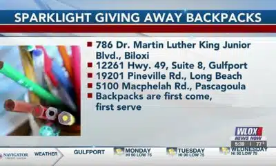
Sparklight offers free backpacks and school supplies to Coast kids

Brain drain: Mother understands her daughters’ decisions to leave Mississippi

29-year-old killed after driving off road in 'dangerous' section road | FOX 5 News

Op-Ed: U.S. District Court rightfully blocked Arkansas’ PBM ban | Opinion
Local artist, Kat Fitzpatrick, breaks down her experience of Hurricane Katrina through her artwor…
Watching the tropics
Gunman allegedly targets CDC over vaccine skepticism

Evening Forecast 8/9/2025

Former payroll director ordered to prison, must repay district nearly $500,000

Urban League's back-to-school expo helps thousands of St. Louis students in need

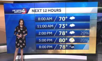
WEEKEND WEATHER AUGUST 9TH

Body of missing NC teen found in Florida, family says

Tropical update: Tracking two disturbances for possible development

Texas migrant detention center to be largest in US
-

 Mississippi Today6 days ago
After 30 years in prison, Mississippi woman dies from cancer she says was preventable
-
News from the South - Texas News Feed6 days ago
Texas redistricting: What to know about Dems’ quorum break
-
News from the South - North Carolina News Feed4 days ago
Two people unaccounted for in Spring Lake after flash flooding
-
News from the South - Florida News Feed7 days ago
Warning for social media shoppers after $22K RV scam
-
News from the South - Georgia News Feed6 days ago
Georgia lawmakers to return this winter to Capitol chambers refreshed with 19th Century details
-
News from the South - Louisiana News Feed6 days ago
Plans for Northside library up for first vote – The Current
-
Local News Video6 days ago
Sparklight offers free backpacks and school supplies to Coast kids
-
Mississippi Today5 days ago
Brain drain: Mother understands her daughters’ decisions to leave Mississippi